
26
Jun

A Complete Expedition Guide
Black Peak • Yunam Peak • Friendship Peak
Permits | IMF Fees | Fitness Requirements | Safety & Precautions
India's Himalayan and trans-Himalayan ranges host dozens of peaks exceeding 6,000 metres. The Indian Mountaineering Foundation (IMF) has designated a special category of "climbable peaks" — summits that, while challenging, do not require the full bureaucratic machinery of an 8,000m expedition. Among the most popular and accessible 6,000m peaks are Black Peak (Kaali Himal) in Uttarakhand, Yunam Peak in Himachal Pradesh, and Friendship Peak also in Himachal Pradesh.
These three peaks serve as excellent stepping stones for alpinists aspiring to higher Himalayan objectives, offering genuine high-altitude challenge, glacier travel, and summit experience without the extreme commitment of the great 8,000m giants. This guide covers everything you need to plan a successful and safe expedition to any of these three peaks.
Altitude: 6,387 m (20,955 ft) | Region: Uttarkashi, Uttarakhand | Range: Garhwal Himalaya
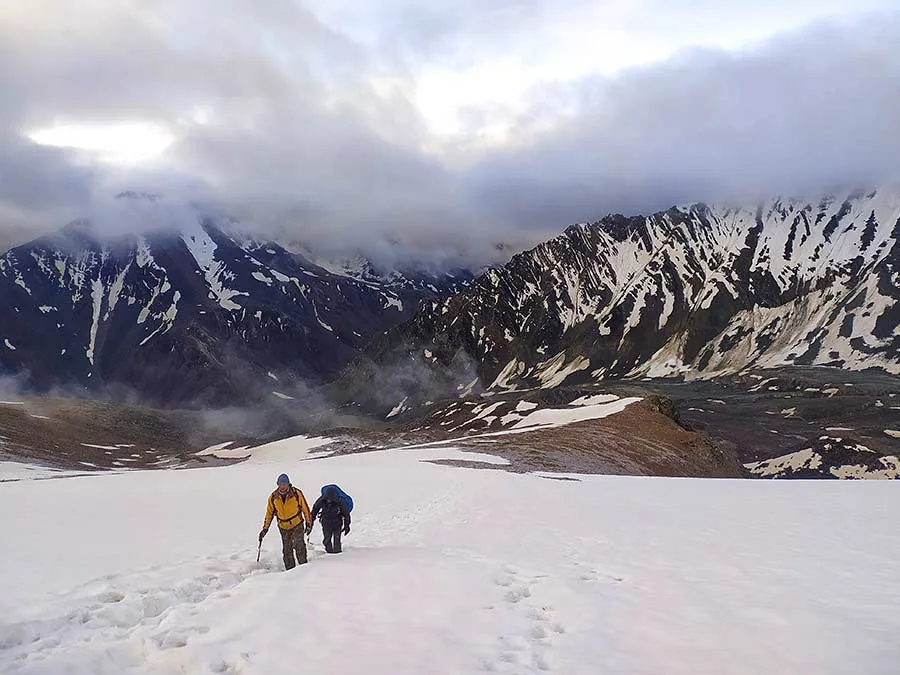
Black Peak, locally known as Kaali Himal, stands at 6,387 metres in the Gangotri group of the Garhwal Himalaya in Uttarakhand. It is one of the most sought-after technical 6,000m peaks in India, offering a classic combination of glacier approach, snowfield climbing, and a mixed rock-ice summit ridge. The mountain is renowned for its striking dark rock bands that give it its English name.
The peak lies in the Har Ki Dun valley region and is accessible via the famous Ruinsara Lake trail. It has been a training ground for elite Indian mountaineers and serves as an excellent acclimatisation objective before tackling peaks like Swargarohini or Bandarpunch.
The standard approach begins from Sankri village (1,920 m), which is the gateway to the Govind Wildlife Sanctuary. The classic route takes 10–14 days round trip from Sankri.
• Day 1–2: Sankri → Taluka → Seema (2,590 m) — forest trail through oak and rhododendron
• Day 3: Seema → Osla village (2,756 m) — traditional Harsil architecture
• Day 4: Osla → Har Ki Dun (3,566 m) — valley walk with views of Swargarohini
• Day 5–6: Rest/acclimatisation, explore Morinda Tal and surrounding ridges
• Day 7: Har Ki Dun → Base Camp at Ruinsara Lake (3,900 m)
• Day 8: Base Camp → Advanced Base Camp (4,800 m) — moraine walk, glacier entry
• Day 9: ABC → High Camp (5,500 m) — steep snowfield ascent
• Day 10: Summit Push from High Camp — mixed terrain, fixed ropes on crux sections, summit (6,387 m)
• Day 11–13: Descent and return to Sankri
|
Parameter |
Details |
|
Grade |
PD+ to AD (Peu Difficile Plus to Assez Difficile) |
|
Max Angle |
45–55° on summit ridge; 35° on approach snowfields |
|
Glacier |
Ruinsara Glacier (moderate crevasse hazard) |
|
Rock |
Mixed granite and schist; some loose sections |
|
Ice |
Blue ice possible near summit in late season |
|
Rappel |
1–2 rappels on descent (20–30 m) |
• Pre-Monsoon: May to mid-June — stable weather, good snow conditions
• Post-Monsoon: September to mid-October — clear skies, cold nights, some ice on upper mountain
• Avoid: July–August (heavy monsoon snowfall, avalanche risk), November–April (extreme cold, deep snow)
The nearest major city is Dehradun. From Dehradun, take a shared taxi or bus to Purola (approx. 5–6 hrs), then another vehicle to Sankri (approx. 2 hrs). Alternatively, the Mussoorie–Nainbagh–Purola road is a scenic option. The Har Ki Dun road is motorable up to Sankri, and beyond that all travel is on foot within the Govind Wildlife Sanctuary.
• Nearest Railhead: Dehradun Railway Station
• Nearest Airport: Jolly Grant Airport, Dehradun (approx. 200 km from Sankri)
• Road: Dehradun → Mussoorie → Purola → Mori → Sankri (approx. 220 km, 9–10 hrs)
Black Peak falls under Govind Pashu Vihar (Govind Wildlife Sanctuary) and requires clearances from both the IMF and the Forest Department.
• IMF Mountaineering Permit: Mandatory. Applied through Indian Mountaineering Foundation, New Delhi.
• Forest Department Entry Permit: Required for Govind Wildlife Sanctuary (obtained at Sankri Check Post)
• Uttarakhand Tourism Registration: All trekkers must register at the Sankri Forest Check Post
• Foreign Nationals: Must also secure Inner Line Permit (ILP) — not applicable as this is not a restricted area, but foreign nationals need prior IMF approval
|
Category |
Indian Nationals (₹) |
Foreign Nationals (USD) |
|
Peak Fee (per team) |
₹ 2,500 – ₹ 5,000 |
$100 – $200 |
|
Royalty Fee (per climber) |
₹ 1,000 – ₹ 2,000 |
$50 – $100 |
|
Liaison Officer Fee |
As applicable |
As applicable |
|
Rescue Deposit |
₹ 25,000 – ₹ 50,000 |
$500 – $1,000 |
Note: Fees are approximate and subject to revision by IMF. Always confirm current rates at www.indmount.gov.in before applying.
Rating: ★★★★☆ | Level: Advanced
• Must have prior experience on peaks of 5,000–5,500 m with glacier travel
• Competence in crampons, ice axe arrest, and basic rope work is mandatory
• Physical fitness: Ability to carry 10–15 kg pack for 6–8 hours at altitude
• Cardio base: Should be able to run 10 km under 60 minutes at sea level
• Prior experience: At least 2 Himalayan treks of 4,500 m+ recommended
• Technical skills: Basic lead climbing (UIAA II–III) is advantageous
Altitude: 6,111 m (20,049 ft) | Region: Lahaul, Himachal Pradesh | Range: Zanskar Range
Yunam Peak (6,111 m) is often called the "easiest 6,000m peak in India" — though this description is relative and should not breed complacency. Located near the Baralacha La pass on the Manali–Leh Highway (NH3) in the Lahaul district of Himachal Pradesh, Yunam is a non-technical, high-altitude snow and scree peak that can be climbed without advanced technical mountaineering skills. This makes it an exceptionally popular objective for those chasing their first 6,000m summit.
The mountain's accessibility (base camp is reachable by road) and relatively straightforward ridge route have made it the highest roadside climbable peak in India. On a clear day, the summit panorama encompasses Mulkila, Deo Tibba, Gepang Goh, and the vast Tibetan plateau.
The approach begins from Manali (2,050 m), driving up to the Baralacha La area on the famous Manali–Leh Highway.
• Day 1: Arrive Manali (2,050 m) — rest, acclimatisation, gear check
• Day 2: Manali → Keylong (3,094 m) — drive via Rohtang Pass (or Atal Tunnel)
• Day 3: Keylong → Sarchu or Baralacha La Base (4,500–4,890 m) — drive
• Day 4: Acclimatisation at Base Camp — short hikes on surrounding ridges
• Day 5: Base Camp → Camp 1 (5,300 m) — gradual ascent on scree and snow
• Day 6: Camp 1 → Summit (6,111 m) → return to Base Camp — 6–9 hr round trip
• Day 7: Buffer/rest day or descent to Manali
Some climbers do a faster schedule (4–5 days from Manali) but risk AMS due to rapid altitude gain. A 7-day schedule is recommended for safety.
|
Parameter |
Details |
|
Grade |
F (Facile / Easy) to PD- |
|
Max Angle |
30–40° on upper snowfield; mostly 20–30° |
|
Glacier |
No technical glacier; snowfield approach |
|
Rock |
Loose scree and boulder on lower approach |
|
Fixed Ropes |
Not required; team ropes useful on summit snowfield |
|
Rappel |
Not required on standard route |
• June to mid-October — road to Baralacha La is open only during this window
• July–August: Road is open but can be prone to flash floods on the highway
• Best Window: Late June to mid-September — stable, snow in good condition
• Avoid: October onwards (road closes, extreme cold), before June (Rohtang/Baralacha passes snowbound)
• Nearest City: Manali, Himachal Pradesh
• Nearest Airport: Bhuntar Airport, Kullu (50 km from Manali)
• Road: Manali → Rohtang (or Atal Tunnel) → Gramphu → Keylong → Jispa → Darcha → Baralacha La (approx. 200 km, 8–10 hrs drive)
• The base camp for Yunam is accessible by road (4WD vehicle recommended); no approach trek required
This roadside accessibility makes Yunam uniquely convenient. Climbers can drive to base camp with full expedition gear without the need for porters on the approach.
Yunam Peak requires a permit from the Himachal Pradesh government and the Indian Mountaineering Foundation. The Lahaul region is open to Indian and foreign nationals.
• IMF Mountaineering Permit: Mandatory — applied through IMF, New Delhi
• District Administration Permit: Lahaul Sub-Division Magistrate, Keylong (can be arranged by operators)
• Forest Permit: Not applicable for this route (outside national park boundaries)
• Foreign Nationals: Restricted Area Permit (RAP) is NOT required for Lahaul district
• Liaison Officer: Required as per IMF norms for foreign expeditions; domestic teams: optional
|
Category |
Indian Nationals (₹) |
Foreign Nationals (USD) |
|
Peak Royalty (per team) |
₹ 1,500 – ₹ 3,000 |
$75 – $150 |
|
Per Climber Fee |
₹ 500 – ₹ 1,500 |
$40 – $80 |
|
Rescue Deposit |
₹ 15,000 – ₹ 25,000 |
$300 – $500 |
|
Environment Fee |
₹ 500 per person |
$10 per person |
Yunam has lower fees compared to Black Peak and Friendship Peak owing to its non-technical nature and domestic focus. Some operators include permit costs in packages.
Rating: ★★☆☆☆ | Level: Beginner to Intermediate
• No technical climbing skills required; basic trekking fitness is sufficient
• Must be comfortable walking with a 8–10 kg pack for 6–8 hours
• Prior altitude experience (3,500–4,500 m) highly recommended to avoid AMS
• Cardio base: Regular aerobic exercise (jogging, cycling, swimming) for 3–4 months prior
• No glacier travel required; crampons and trekking poles are the primary gear
• Ideal first 6,000m peak for trekkers making the transition to mountaineering
Altitude: 5,289 m (17,352 ft) — Peak | Solang Nala area summit ~6,000 m |
Note: Friendship Peak is commonly listed at 5,289 m in most maps, but the broader Friendship Peak massif and its highest point are sometimes cited up to 5,900–6,000+ m in local expedition contexts. In this guide, we cover the full Friendship Peak Expedition as a 6,000m-class alpine objective (high camp approaches reach 5,800–6,000 m), which is how most expedition operators classify it.
Region: Kullu, Himachal Pradesh | Area: Solang Valley, near Manali | Range: Pir Panjal / Kullu Himalaya
Friendship Peak is one of the most accessible and charming alpine peaks near Manali, located in the Solang Valley in Himachal Pradesh. It is a popular introductory mountaineering summit, combining a beautiful glacier approach with moderate technical climbing. The peak offers stunning views of Deo Tibba, Hanuman Tibba, and the Rohtang Pass region.
The name itself reflects the spirit of mountain camaraderie. The peak is a favourite destination for mountaineering institutions, adventure tourism operators, and mountaineers from across India making their first foray into roped glacier climbing. It is perfect as a stepping stone before attempting more serious peaks like Deo Tibba or Indrasan.
• Day 1: Arrival Manali (2,050 m) — gear check, team briefing, acclimatisation walk
• Day 2: Manali → Solang Nala (2,480 m) → trek to Dhundi Camp (2,900 m)
• Day 3: Dhundi → Base Camp at Beas Kund (3,700 m) — beautiful glacial lake
• Day 4: Acclimatisation at Base Camp — load carry to moraine camp, crevasse training
• Day 5: Base Camp → Advanced Base Camp / Camp 1 (4,500 m) — glacier walk
• Day 6: Camp 1 → High Camp (5,100–5,300 m) — snow and mixed terrain
• Day 7: Summit Push — High Camp to summit (~5,289–6,000 m class high point) and return
• Day 8: Descend to Manali
|
Parameter |
Details |
|
Grade |
PD (Peu Difficile) — Moderate |
|
Max Angle |
40–50° on summit ridge; 30° on glacier approach |
|
Glacier |
Yes — Friendship Glacier with moderate crevasse risk |
|
Rock |
Mixed rock/snow on upper section |
|
Fixed Ropes |
Set by guides on crux summit section |
|
Rappel |
1 rappel (~15–20 m) on descent |
• April to June: Spring window — good snow, but some unstable weather possible
• September to October: Post-monsoon — clearest skies, cold nights, solid ice
• Best Overall: May and October — stable weather and good visibility
• Avoid: July–August (monsoon precipitation, high avalanche risk)
• Nearest City: Manali, Himachal Pradesh
• Nearest Airport: Bhuntar Airport, Kullu (50 km from Manali)
• Nearest Railhead: Jogindernagar (125 km) or Pathankot (300 km)
• Road: Manali → Solang Valley → Dhundi (12 km from Manali, motorable by 4WD)
Friendship Peak is the most conveniently located of the three peaks covered in this guide, with the trailhead just 12 km from Manali town. Expedition base camp at Beas Kund can be reached in a single day from Manali.
• IMF Mountaineering Permit: Mandatory for all expeditions
• HP Forest Department Permit: Solang Valley falls partly in protected forest
• Manali Forest Division Clearance: Required — obtained from DFO office in Manali
• HPTDC/District Registration: For trekkers camping in the zone
• Foreign Nationals: No Restricted Area Permit required; IMF permit is sufficient
• Liaison Officer: Required for foreign teams per IMF regulations
|
Category |
Indian Nationals (₹) |
Foreign Nationals (USD) |
|
Peak Royalty (team) |
₹ 2,000 – ₹ 4,000 |
$80 – $160 |
|
Per Climber Fee |
₹ 750 – ₹ 1,500 |
$40 – $90 |
|
Rescue Deposit |
₹ 20,000 – ₹ 30,000 |
$400 – $600 |
|
Environment/Garbage |
₹ 500 per person |
$10 per person |
Rating: ★★★☆☆ | Level: Intermediate
• Basic mountaineering skills required: crampon use, ice axe arrest, rope management
• Prior high-altitude trekking experience (4,000–5,000 m) is essential
• Glacier travel competence is important — crevasse awareness and rope-team protocol
• Physical fitness: 6–8 hour days with a 10–12 kg pack
• Cardio base: Should train for 3–4 months with hiking, stair climbing, and running
• Ideal for trekkers who have completed basic mountaineering courses (BMC/AMC)
The following table provides a comprehensive at-a-glance comparison to help you choose the right objective based on your experience, fitness, time, and budget.
|
Parameter |
Black Peak |
Yunam Peak |
Friendship Peak |
|
Altitude |
6,387 m |
6,111 m |
~5,289–6,000 m class |
|
State |
Uttarakhand |
Himachal Pradesh |
Himachal Pradesh |
|
Range |
Garhwal Himalaya |
Zanskar Range |
Pir Panjal/Kullu |
|
Difficulty |
Advanced (PD+/AD) |
Beginner (F/PD-) |
Intermediate (PD) |
|
Duration |
12–14 days |
6–8 days |
8–10 days |
|
Glacier Travel |
Yes (significant) |
No |
Yes (moderate) |
|
Max Slope |
45–55° |
30–40° |
40–50° |
|
Road Access |
To Sankri; then trek |
Direct to Base Camp |
To Dhundi; 1 day trek |
|
Best Season |
May–Jun, Sep–Oct |
Jun–Sep |
May–Jun, Sep–Oct |
|
IMF Fees (Indian) |
₹3,500–7,000+ |
₹2,000–4,500+ |
₹2,750–5,500+ |
|
IMF Fees (Foreign) |
$150–$300+ |
$115–$230+ |
$120–$250+ |
|
Fitness Level |
★★★★☆ Advanced |
★★☆☆☆ Beginner |
★★★☆☆ Intermediate |
|
Technical Skills |
Mandatory |
Not required |
Basic required |
|
Base Camp Alt. |
3,900 m (Ruinsara) |
4,500–4,890 m |
3,700 m (Beas Kund) |
|
Crowd Level |
Low–Moderate |
Moderate–High |
Moderate |
|
Ideal For |
Experienced alpinists |
First 6,000m summit |
BMC/AMC graduates |
The Indian Mountaineering Foundation (IMF), established in 1958, is the apex body regulating mountaineering in India. All expeditions to peaks listed in the IMF peak directory require a permit issued by IMF. Here is a detailed step-by-step guide to the process.
• Visit the IMF official website: www.indmount.gov.in
• Confirm the peak is open for the season you intend to climb
• Check if any prior bookings have been made for your intended dates (some peaks have queue systems)
• Contact IMF directly at: Benito Juarez Road, New Delhi – 110021, Phone: 011-24119055/56
• Minimum team size: Generally 4 climbers (varies by peak)
• Appoint a Team Leader who will be the official applicant
• Ensure all members have valid IMF membership (annual or life membership)
• For foreign nationals: Ensure valid Indian visa with 'Multiple Entry' if entering from Nepal
• Duly filled IMF Expedition Application Form (downloadable from IMF website)
• Medical fitness certificate from a registered physician (for each team member)
• Proof of prior mountaineering experience (summit certificates, logbooks, or NIM/HIM certificates)
• Two passport-sized photographs per member
• Copy of passport/Aadhaar for identity verification
• Insurance certificate covering high-altitude rescue (mandatory — minimum $50,000 coverage for foreign nationals)
• List of equipment, including communication devices
• Submit the application in person or by post to IMF headquarters in New Delhi
• Online applications may be available for certain peaks — check IMF website
• Pay the applicable peak royalty fee, rescue deposit, and environment fee via demand draft or NEFT
• Processing time: 2–4 weeks for domestic expeditions; 4–8 weeks for foreign expeditions
• Uttarakhand peaks (Black Peak): Obtain Forest Department/Sanctuary entry permit from local DFO
• Himachal Pradesh peaks (Yunam, Friendship): Obtain HP Forest/District permit from relevant SDM/DFO
• Protected Area Permit (PAP): Not required for these three peaks for Indian nationals
• Restricted Area Permit (RAP): Not required for these three peaks
• Foreign expeditions must accept an IMF-appointed Liaison Officer (LO)
• LO salary and logistics (food, accommodation, equipment) are the expedition's responsibility
• LO fee typically: ₹8,000–15,000/month (government staff on deputation)
• Indian expeditions: LO is optional for peaks below 6,500 m in most categories
• Once approved, collect the permit letter from IMF (in person or by post)
• Carry original permit, photocopies, and team ID documents at all times
• Show permit at forest check posts, District Administration offices, and army check posts
• Permit must be returned after expedition with a post-expedition report
Altitude is the great equalizer. Even the fittest athletes can succumb to altitude-related illness if they ascend too fast or ignore warning signs. Below are critical precautions, organized by category, that every expedition member must know and follow.
• Climb High, Sleep Low: Ascend during the day, return to lower camp to sleep
• Do not ascend more than 300–500 m in sleeping altitude per day above 3,000 m
• Build in rest days: At least one rest day every 3–4 days of ascent
• Recognize the 'Lake Louise Score' for AMS: Headache + any of (fatigue, GI disturbance, dizziness, sleep disturbance) = AMS
• NEVER ascend with symptoms of AMS — this risks progression to HACE or HAPE
• Headache (primary symptom) — throbbing, often worse at night
• Nausea or vomiting, loss of appetite
• Fatigue disproportionate to exertion
• Dizziness or lightheadedness
• Sleep disturbance — insomnia or periodic breathing (Cheyne-Stokes)
Treatment: If AMS symptoms appear — STOP ascending. Rest at current altitude. Take Ibuprofen or Paracetamol for headache. Descend 500–1,000 m if symptoms worsen. Do NOT take Diamox as a preventive measure without consulting a doctor.
• Severe headache that does not respond to medication
• Ataxia (loss of coordination — test with tandem gait walk)
• Altered mental status, confusion, extreme lethargy
• Action: IMMEDIATE descent of at least 1,000 m. Administer Dexamethasone (8 mg IV/IM if available). Use Gamow bag if available. Evacuate to hospital.
• Shortness of breath at rest (not just on exertion)
• Dry cough progressing to frothy or blood-tinged sputum
• Reduced exercise tolerance, fatigue
• Cyanosis (blue lips or fingernails in severe cases)
• Action: IMMEDIATE descent. Administer Nifedipine (30 mg slow-release) if available. Supplemental oxygen. Evacuate urgently.
• Layer clothing system: Base layer (moisture-wicking), mid layer (insulation), shell (waterproof/windproof)
• Keep extremities covered at all times above 5,000 m — liner gloves + expedition mitts
• Recognize frostbite: white or grey waxy skin, numbness, then hardening of tissue
• Do NOT rub frostbitten tissue — wrap in dry sterile bandage and descend
• Rewarm frostbitten tissue only if refreezing is impossible — thaw-refreeze is catastrophic
• Stay dry — wet clothing loses 90% of its insulation value
• Drink 4–6 litres of fluid per day at altitude — dehydration worsens AMS
• Urine colour test: Pale yellow = well hydrated; dark yellow = dehydrated
• Avoid alcohol and sleeping pills — both suppress breathing and worsen altitude adaptation
• Eat even when you have no appetite — your body needs calories for thermoregulation
• Carry high-calorie snacks: nuts, chocolate, energy bars for summit day
• Study slope angle: Avalanches most common on 30–45° slopes
• Travel early morning — snow is more stable before solar heating softens the surface
• Identify and avoid convex rolls, cornices, and avalanche debris from prior events
• Each team member should carry: Avalanche transceiver (beacon), probe, and shovel
• Know burial rescue protocol: Switch all beacons to Search, organized probe line, excavate from downhill side
• Never cross avalanche terrain during or after heavy snowfall or rapid temperature rise
• Always rope up on glaciers — crevasses can be hidden under thin snow bridges
• Rope spacing: 8–10 m on glaciers; 4–6 m on technical terrain
• Establish fixed ropes on sections steeper than 40° or where falls would be fatal
• Ice axe technique: Practice self-arrest before the expedition, not during
• Crampon discipline: Check crampon fit daily; anti-balling plates prevent snow clumping
• Helmet: Mandatory on technical terrain with rockfall or icefall exposure
• Weather window: Never push for summit in deteriorating weather — summit is optional, return is mandatory
• Carry a satellite phone or PLB (Personal Locator Beacon) on all expeditions
• Register with local rescue coordination (SDRF Uttarakhand / HP Police) before departure
• Leave a detailed trip plan with a responsible contact person with exact return date
• Know the nearest helicopter rescue base: For Uttarakhand — Gauchar/Dehradun; for Himachal — Kullu/Chandigarh
• Have emergency contact numbers pre-saved: IMF Emergency, SDRF, High Altitude Rescue Team (HART)
Fitness for high-altitude mountaineering is multi-dimensional. It encompasses cardiovascular endurance, muscular strength, technical skill, and psychological resilience. Below is a detailed fitness framework with labels for each peak.
|
Label |
Rating |
Description |
|
Beginner |
★★☆☆☆ |
Regular trekker with 3,500–4,500 m experience. No technical skills required. Strong general fitness. |
|
Intermediate |
★★★☆☆ |
Trekker-mountaineer with 4,500–5,200 m experience. Basic crampon, ice axe, and rope skills. Completed BMC/AMC course. |
|
Advanced |
★★★★☆ |
Experienced alpinist with prior 5,500–6,000 m summits, glacier travel, mixed climbing, and multi-day expedition experience. |
|
Expert |
★★★★★ |
Full alpine competence. Leads technical pitches, crevasse rescue capability, independent route-finding on 6,000+ m terrain. |
• Months 1–2: 3–4 sessions/week of aerobic cardio (jogging, cycling, swimming) — 45–60 min sessions at 65–75% max heart rate
• Month 3: Introduce altitude simulation — stair climbing with weighted pack (10–15 kg), hill running
• Month 4 (taper): Reduce volume by 30%, maintain intensity — preserve fitness without fatigue
• Weekly long hike: One 6–8 hour hike with 800–1,000 m elevation gain per week throughout
• Core: Planks, dead bugs, Russian twists — 4×/week for lower back and abdominal stabilisation
• Legs: Squats, lunges, step-ups with loaded pack — mimics uphill movement patterns
• Upper body: Pull-ups, rows, shoulder press — for hauling packs and using trekking poles/ice axe
• Grip strength: Farmer's walks, dead hangs — critical for ice axe and rope handling
• Enrol in NIM (Nehru Institute of Mountaineering), HIM (Himalayan Institute of Mountaineering), or ABVIMAS basic/advanced mountaineering course
• Practice crampon walking on snow/ice slopes of 20–40°
• Master ice axe arrest — practice on safe snow slopes before the expedition
• Rope coiling, knots (figure-8, clove hitch, prussik), and belay practice
• Crevasse rescue drill with your team before departure
|
Fitness Test |
Black Peak |
Yunam Peak |
Friendship Peak |
|
10 km run time |
< 60 min |
< 75 min |
< 65 min |
|
Pack weight |
12–15 kg |
8–10 kg |
10–12 kg |
|
Daily hrs at altitude |
7–10 hrs |
5–7 hrs |
6–8 hrs |
|
Prior altitude |
5,500 m+ summit |
4,000–4,500 m trek |
5,000 m+ trek |
|
Technical skills |
Advanced (mandatory) |
None required |
Basic (mandatory) |
|
Glacier experience |
Yes (essential) |
No |
Yes (basic) |
• Moisture-wicking base layer (top and bottom) — merino wool or synthetic
• Mid-layer insulation — fleece jacket and down vest or light down jacket
• High-altitude down jacket (rated to -20°C or lower) — for Black Peak and high camps
• Waterproof/windproof hardshell jacket and pants — Gore-Tex or equivalent
• Expedition-weight down pants — for Black Peak high camps and summit day
• Trekking pants (2 pairs), moisture-wicking T-shirts (3–4), thermal underwear
• Balaclava, warm hat, and sun hat; buff/neck gaiter
• Liner gloves + insulated ski gloves + expedition mitts (3-layer system)
• Trekking socks (wool, 4–6 pairs) + warm camp socks
• Double plastic boots or stiff mountaineering boots rated to -30°C (Black Peak mandatory; recommended for Friendship Peak)
• Approach shoes or trekking boots for lower elevations
• 12-point crampons — step-in or bail binding, compatible with your boots
• Gaiter (high-ankle waterproof) for snow and scree sections
• Ice axe — standard (60–65 cm) for general alpine use; technical axe for Black Peak crux
• Helmet — CE-certified climbing helmet
• Harness — alpine harness with gear loops
• Belay device (ATC or equivalent) + HMS locking carabiner
• 4–6 locking carabiners, 4–6 non-locking carabiners
• 2 x 120 cm slings + 1 x 60 cm sling per person
• Crevasse rescue kit: Prussik cords (6 mm × 5 m, ×2), pulley, ice screws (×2)
• Rope: 9–10 mm × 50–60 m dry-treated rope (team equipment)
• Avalanche transceiver (beacon), probe (240 cm+), and shovel — mandatory for glacier travel
• 4-season tent (rated to -20°C winds) — doubles as base camp and high camp shelter
• Sleeping bag rated to -20°C or lower (expedition-grade down)
• Sleeping pad — insulating foam or inflatable with R-value 4.0+
• Stove + fuel canisters (at altitude, gas performance drops — carry extra)
• Cooking pot, mug, spork, lighter (×2) and waterproof matches
• Topographic map of the area + compass
• GPS device or GPS-enabled watch (downloaded offline maps)
• Headlamp (×2 per person) with extra batteries — summit day starts at 2–3 AM
• Sunglasses (CE category 4) and snow goggles — snow blindness risk is severe
• Sunscreen SPF 50+ and lip balm with SPF — UV radiation doubles at 6,000 m
• Satellite communicator or PLB (Personal Locator Beacon)
• Ibuprofen (400–600 mg), Paracetamol — for headache management
• Diamox (Acetazolamide) — only on medical prescription; not for prophylactic use without advice
• Dexamethasone (8 mg) — emergency HACE treatment; carry even if not prescribed for routine use
• Nifedipine (30 mg slow-release) — emergency HAPE treatment
• Blister kit, moleskin, medical tape, sterile bandages and gauze
• Antiseptic cream and antibiotic course (prescribed)
• Gamow bag — optional but life-saving for serious HACE/HAPE (usually carried by organized operators)
IMF permits for popular windows (May–June, September–October) can get allocated quickly, especially for international expeditions. Apply at least 3–4 months before your intended climb date.
Even experienced climbers benefit immensely from local guides and high-altitude porters. They know route conditions, weather patterns, and emergency evacuation routes. For Black Peak and Friendship Peak especially, a certified mountain guide is strongly recommended.
Spend at least 2–3 nights in a town at 2,000–3,000 m (Manali, Keylong, Sankri) before ascending to base camp. This dramatically reduces AMS risk and improves performance.
Helicopter rescue from 5,000–6,000 m costs ₹3–10 lakh (and much more for international evacuations). Ensure you have comprehensive adventure travel insurance covering high-altitude rescue and repatriation. Check that your policy explicitly covers peaks above 5,000 m.
The Himalaya faces enormous environmental pressure. Carry all waste back to base camp and ultimately out of the mountains. Use biodegradable soap only. Do not disturb wildlife, cut vegetation, or leave fixed ropes/rubbish on the mountain. IMF's clean expedition guidelines are mandatory and are part of your permit obligations.
• NIM — Nehru Institute of Mountaineering, Uttarkashi, Uttarakhand (www.nimindia.net)
• HIM — Himalayan Institute of Mountaineering, Darjeeling, West Bengal
• ABVIMAS — Atal Bihari Vajpayee Institute of Mountaineering & Allied Sports, Manali, HP
• JIM — Jawahar Institute of Mountaineering, Pahalgam, J&K
• SIMSAS — Sonam Institute of Mountaineering, Leh, Ladakh