Trek difficulty
Difficult
Trek duration
11-12 Days
Trek altitude
17257 Ft.
Group size
6-12
Trek distance
61 km
Basecamp
Joshimath
Best Time
May to June & September
Pickup Point
Dehradun
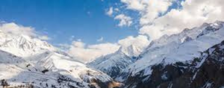
This Expedition is really tough and takes place in a very remote area of the Indian Himalayas , it is located in the Garhwal region and connects Badrinath to Kedarnath.The route involves glacier crossings, steep snowfields, and very technical mountain terrain.It is known as the “Mother of All Treks” because of how difficult it is.Participants need to be very fit, strong, and experienced in high-altitude trekking or mountaineering.The route offers views of major Himalayan peaks like Neelkanth, Balakun, and Chaukhamba.Climbers must deal with extreme conditions and continuous glacier travel.
The Panpatia Col trek connects the holy pilgrimage sites of Kedarnath and Badrinath and is one of the most complicated and challenging treks in the Garhwal Himalayas. This high-altitude pass sits at a staggering altitude of 5,260 m (17,260 ft), sandwiched between two unnamed peaks that climb to 5,500 m+.
A myth holds that priests used this route to travel between Kedarnath (Lord Shiva's place) and Badrinath (Lord Vishnu's place) in a single day — hence it was seen as a divine shortcut known only to saints. Over time, the path was forgotten and turned into legend.
British explorers like Tilman and Eric Shipton first set foot here in 1934, entering through the Satopanth glacier, but got trapped in the dense bamboo forest of Gondharpongi valley. Harish Kapadia attempted it in 1997 but was stopped by the icefall. In 2000, English mountaineer Martin Moran successfully negotiated the Panpatia icefalls, completing Shipton's route.
In 2007, a Bengali team led by Tapan Pandit and Debabrata Mukherjee successfully crossed the crevasse-laden icefields of the Panpatia, creating history as the first Indian success on the route. Their use of Google Earth helped plan a safer path, and this route became the template for modern trekkers.
Key Highlights
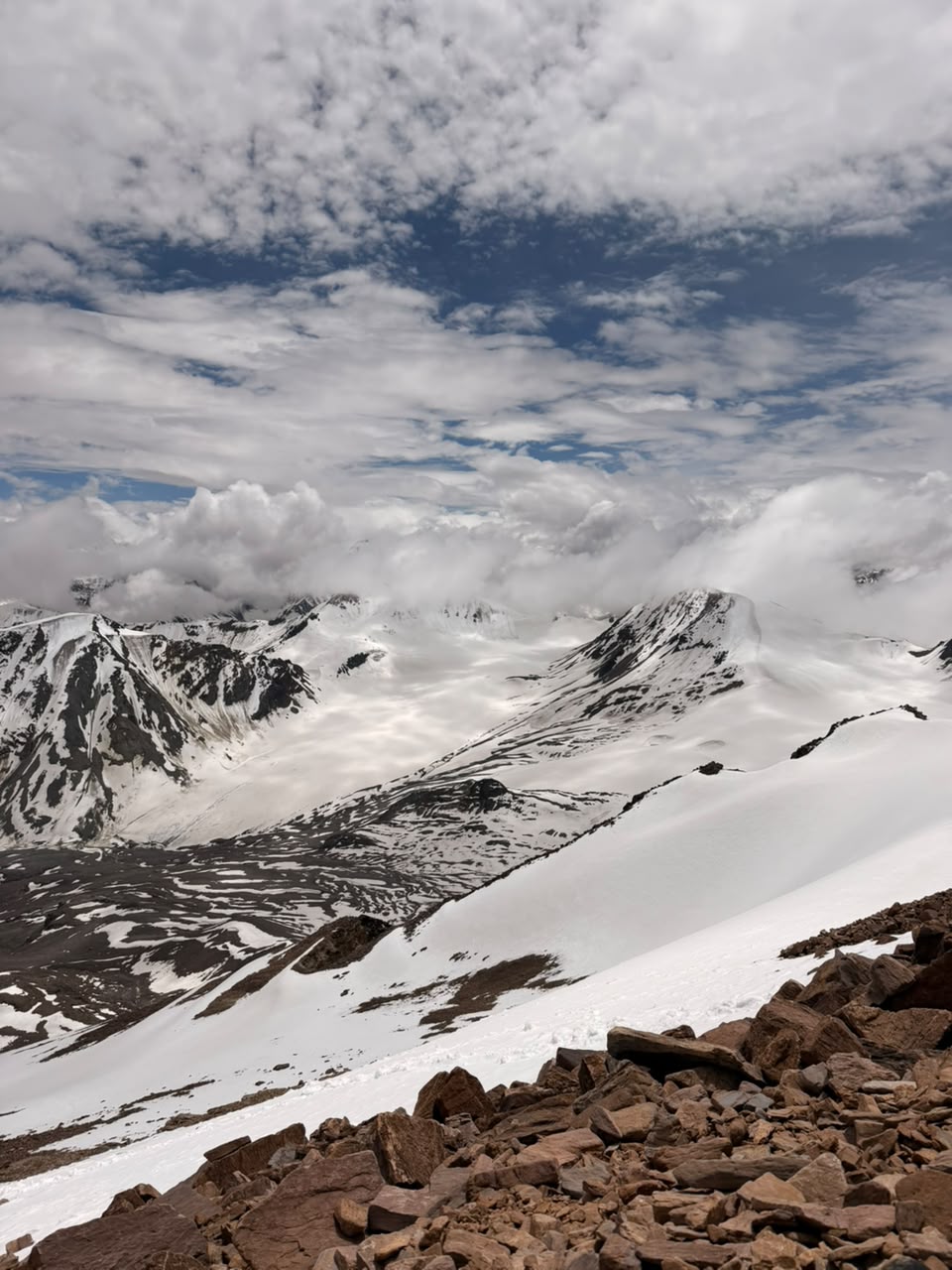
Terrain & Landscape The trek spans approximately 76 kilometers and traverses rugged terrain, glaciers, and a high mountain pass. The Panpatia snowfield is a vast expanse of snow and ice offering an otherworldly landscape.
Glacier & Snowfield The path passes by huge glaciers, crevassed snowfields, rugged moraines, and a never-ending 7-kilometer-long Panpatia snowfield — a delight for aspirational trekkers.
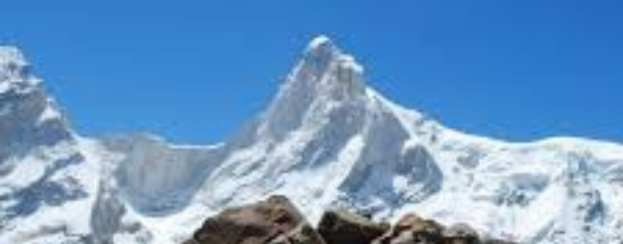
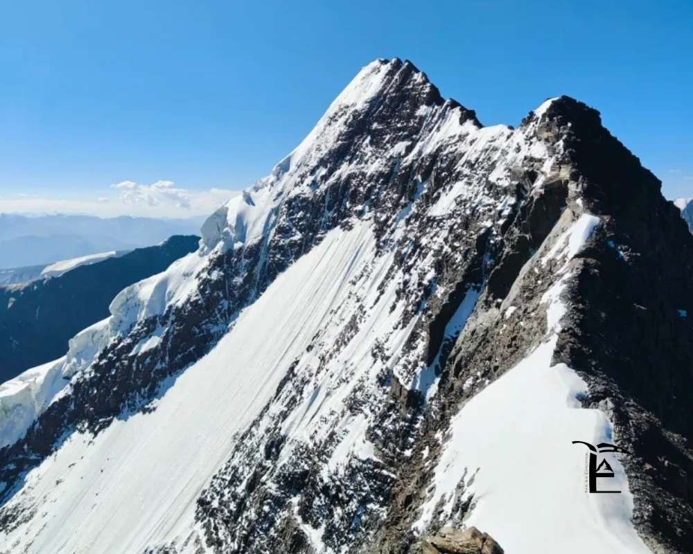
Panoramic Peak Views The expedition offers unparalleled views of prominent peaks such as Neelkanth, Balakun, Sri Parvat, Kunaling, Hathi Parvat, and Dhauliganga Peaks. On clear days, the mighty Chaukhamba and even Nanda Devi are visible.
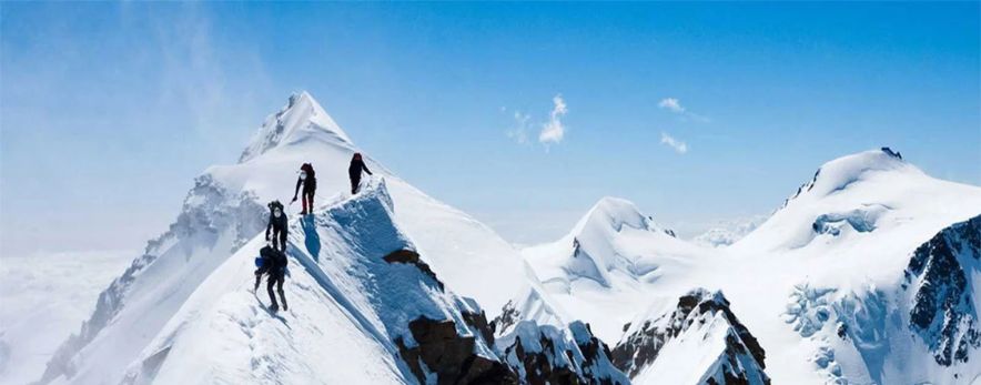
Parvati Gully & Col Climbing up the Parvati Gully is perhaps the trickiest section of the whole trail — a steep rocky climb with melting ice trickling off the rocks offering little purchase. From Parvati Col, trekkers veer off towards the Panpatia icefield.
The Col Itself Panpatia Col is actually a series of two passes — a col "up" that leads into the snowfield, and a col "down" for exit.
Sujal Sarovar & Spiritual End After crossing the col, trekkers descend to camp near the small lake of Sujal Sarovar. The route then continues toward Madhyamaheshwar, one of the sacred Panch Kedar temples.
Day 1: Dehradun to Joshimath (300 km Drive)
Day 2: Joshimath to Alaknanda Camp (8,530 ft) via Khirao
Day 3: Alaknanda Camp to Shepherd Camp (11,745 ft)
Day 4: Shepherd Camp to Snout Camp (12,860 ft)
Day 5: Snout Camp to Moraine Camp (14,107 ft)
Day 6: Moraine Camp to Parvati Gully Base Camp (15,091 ft)
Day 7: Parvati Gully Base Camp to Panpatia Snowfield Camp (17,125 ft) via Parvati Col (16,732 ft)
Day 8: Panpatia Snowfield Camp to Sujal Sarovar (15,551 ft) via Panpatia Col (17,257 ft)
Day 9: Sujal Sarovar to Kachni (13,648 ft)
Day 10: Kachni to Nanu Chatti (10,695 ft)
Day 11: Nanu Chatti to Ransi (6,397 ft) – Drive to Rudraprayag
Day 12: Reserve Day
The expedition , should be attempted only when the weather is stable and calm.
Recommended Months:
These months provide a good balance of stable weather and accessible routes.
This trek is only for seasoned trekkers and aspiring mountaineers who have previous trekking experience and knowledge of using ice axes, crampons, and roping up procedures. It necessitates a high degree of health, as well as physical and mental stamina.
Services of a mountaineering-certified guide are a must. Use of ropes, crampons, harness, carabiners, and descenders will come into play during the trek. Trekkers should have experience of at least 4–5 high-altitude treks.
Mountaineering Gear
Clothing
Personal Essentials
During The Trek Exclusion
Panpatia Col is not an idea for people who are trekking for the first time. This trek is very tough. You need to know a lot about high mountains and climbing. You have to be very fit and able to handle situations. Panpatia Col is a challenge and you should only try it if you have been on tough treks before and know how to deal with high altitude. You need to be, in shape and have a strong mind to make it through this trek. Panpatia Col requires a lot of experience and skill.
The Panpatia Col is really tough. This route has a lot of things that make it hard like glaciers and crevasses and steep snow slopes. You also have to walk for a time every day. So only people who have a lot of experience, with trekking and mountaineering should try the Panpatia Col.
The best time to try to cross Panpatia Col is in May and June. Then again in September. These months are usually pretty calm. The snow is not too bad.
It is situated in the Chamoli district of Uttarakhand , the Panpatia Col is between the Nanda Devi and the Chaukhamba ranges in the Garhwal Himalayas.
The Panpatia Col expedition usually takes 26 to 28 days to complete , this duration includes travel days, acclimatization, buffer days, and the actual crossing of the pass.
₹On Demand | $On Demand
27 Days
Uttarakhand
45Km
May to June | September to October
₹On Demand | $On Demand
11-12 Days
Uttarakhand
61 km
May to June & September
₹38000 | $500
8 Days
Himachal Pradesh
22 km
June to September
₹On Demand | $On Demand
8 Days
Himachal Pradesh
42 Km
July & August
₹On Demand | $On Demand
9-10 Days
Ladakh
72
July to September
₹70000 | $800
15 Days
Uttarakhand
72 Km
May to June and September to October
Testimonials

Rakesh dulams
Nice experience with the thinAir expedition and accommodation and hospitality and safty such as taken personal care and well experienced guide and such a cool guy

Aditi 99
I had an amazing experience with thin air expeditions. The food, the hospitality, and the preparedness of the staff for all sorts of scenarios was commendable. The location of camps was perfect. Even though i was a female solo traveller , i felt very safe and comfortable. Couldn’t have asked for a better team.

Radandi Shashank
“You are not just a mountain trek guides, but a true guardian of the journey. Your unwavering loyalty to our team, the mountains, and safety itself is extraordinary. Every step felt secure because of your dedication, integrity. And stayed committed to every trekker, through every challenge, with patience, care, and honesty. Huge respect to Subodh Jii n Aditi Mam!! Thank youu @thinairexpedition It was wonderful experience!!❤️❤️

67D3_KALYAN
Completing the Kedarkantha trek at an altitude of around 12,500 feet was not just a trek for us, it was a life-long memory, and a major reason for this unforgettable experience is our guide Shubhod Sir. From the very first day till the summit, Shubhod Sir guided us with immense patience, discipline, and genuine care. At every difficult patch, when our legs were tired and breathing became hard, his calm words, constant motivation, and confident leadership gave us the strength to keep moving forward. He never rushed anyone and always made sure that every member of the group was safe, comfortable, and mentally strong. Shubhod Sir’s knowledge of the mountains, weather, and high-altitude conditions was truly impressive. More than a guide, he felt like a protector and mentor who treated everyone like family. His positive attitude and humble nature created a sense of trust and confidence among all of us. We are also thankful to Atidhi Madam for her support and cooperation during the trek, which added to the smooth experience. Because of Shubhod Sir’s guidance and dedication, we successfully reached the summit with confidence and joy. We will always remember this trek with gratitude and respect. Truly blessed to have a guide like him. 🙏⛰️

Arvind Sahu
Wonderful experience totally worth it. At those price they provided services that no one could provides really enjoyed ❤️🎉

Kolanu Anirudh
This is my first trek in Uttarakhand(Kedharkanta) and Thin Air Expedition made it a memorable one Thanks for everything subodh bro you made it so special.

kanica kandpal
Completed the Gaumukh–Tapovan trek with Thin Air Expedition, and it was an exceptional experience from beginning to end. Instead of opting for a fixed-departure model, we chose a personally curated itinerary, as this was our first trek—and it turned out to be the perfect decision. The team was extremely thoughtful in planning each day’s distance, ensuring we were comfortably challenged without ever feeling overtired or exhausted upon reaching the campsites. Every campsite was carefully selected, offering not just safety and comfort but also breathtaking views that made each halt truly memorable. What stood out most was the level of personalization. The itinerary was clearly tailored to our pace and comfort, and the trek leader constantly shared insightful facts about the region, its geography, and cultural significance, adding depth and meaning to the journey. Overall, Thin Air Expedition delivers a highly personalized, well-paced, and enriching trekking experience. I would highly recommend them, especially for first-time trekkers looking for a safe, informative, and thoughtfully curated adventure.Sen

Raj Bahadur
I booked my trek with Thin Air Expedition on a friend’s recommendation, and it turned out to be a great decision. They managed travel and accommodation very smoothly, and everything was well organized throughout the journey. The team stayed in regular coordination, ensuring that stays and drivers were properly arranged each day. The entire trip was timely, hassle-free, and also pocket-friendly. I would definitely recommend Thin Air Expedition—you can trust them completely with your travel and trekking plans.

sachin aulakh
I recently completed the Kedarkantha Trek with ThinAirExpedition, and the entire experience was outstanding. The coordination, communication, and arrangements were excellent. The trek leaders were experienced and friendly, the support staff was humble, the stay was comfortable, and the food quality in such high altitude conditions was truly impressive. Their focus on safety and responsible trekking made the journey even better. I would definitely choose them again for my next Himalayan adventure! 🏔️✨

Aman rai
I recently completed a trek with the help of ThinAirExpedition, and the entire experience was very comfortable. From stay arrangements to travel from Rishikesh to Rishikesh, everything was well managed. The driver was extremely polite, supportive, and made the journey smooth and stress-free. Overall, a great experience and I would definitely recommend them.

Nitya Jaiswal
Kedarkantha was not just a trek, it was an experience that helped me reconnect with myself. Thanks to Thin air expeditions , I felt safe, cared for and encouraged at every step. The sunrise at the summit, the laughter around the campfire and the kindness of the guides will stay with me forever. If you're looking for a company that treats you like family on the mountains, this is the one.

Biswajit Sahoo
Subodh Sir making the trek so much of fun and intresting .. Awesome Experience with Subodh Sir

Anmol Verma
Overall trekking and accommodation was a very smooth experience. Our trek leader Mr. Ramesh was amazing and very helpful. He managed to make the trek look easy. Overall experience was 10/10. Would highly recommend.

Rishabh Singh Rana
Trek Guide Mr. Ramesh Ji is a very cool & good person. Trek journey became beautiful with the group and overall it became my one of the best experience.

aditi vaidya
I recently went on a trek with Thin Air Expeditions, and I can't get over the experience I had! I did the Phulara Ridge trek with Subodh sir, and it was an incredible experience. What made it even more special was that Subodh sir made sure I could bring my dog, Flake, a toy pom. His team and him took such great care of us, and it was clear that they truly care about their guests, human or canine! The group was amazing too. I met some wonderful people along the way, and we formed lifelong bonds. The whole experience was beautiful – from the breathtaking views to the friendly, supportive environment. I’ll cherish these memories forever! If you're looking for a SAFE, well-organized, fun, and caring trekking company, Thin Air Expeditions and Subodh sir are the ones to go with!

Anuja Vaidya
It was a wonderful experience with TAE on Phulara ridge trek, everything was on point the gears, food, trek guides and Subodh sir himself was an amazing leader who is the founder of TAE, he made sure the experience was amazing even for the first timers keeping safety the first priority. Also I took my Dog, Flake along with me for the trek and it was a great experience for her as well and her food and safety was well taken care of . 🐾 Would love to go back again with Thin air expedition. Thank you so much 🤗

Simran Samal
Phulara Ridge Trek – A Memorable Experience for me !!! Someone once told me, “Trips aren’t just about travel — they become a part of you.” I never really believed it, but this time, Phulara Ridge became exactly that for me. Our first campsite — the forest trail, the tents, the whole setting — gave me the first taste of what was to come. Everything was so thoughtfully arranged, it felt like nature itself had prepared that space for us. All thanks to our trek leader, Subodh bhai 🙌🏻. The next stop was magical in its own way. The campsite was picture-perfect, and we even ended up learning a bit of the local Uttarakhandi dance from Dev bhaiya (well… I tried to! 😄). In the evenings, we played games and spent such a good time that we forgot the weight of city life for a while. And finally, the Ridge: Honestly, we thought the weather would block the views, but Subodh bhai timed it so perfectly that the skies cleared for us. Walking on the ridge — one valley on the right, another on the left, clouds passing beneath us — felt surreal. We sat there for hours, just soaking it all in. It was pure peace. And yes, we even made tea there!!! 🫶🏻 (Of course, we made no mess, cleaned it all up, and left the space exactly the way it should be 😌). For me personally, trekking has always been like meditation — a way to quiet the noise and reconnect with myself. This trek with Subodh bhai and the team gave me exactly that: peace, perspective, memories for a lifetime, and inspiration. #SoGrateful 🙏🏻 Thank you, Subodh bhai and team, for making this such a soulful and unforgettable journey! Lastly Just one note for all: “In the end, we don’t conquer mountains; they help us discover who we truly are.” To anyone even considering it: please go with #ThinAir Expeditions to experience the rawness of trekking, the beauty of nature, and the joy of escaping city life for a while. You’ll come back not just with pictures, but with stories, stillness, and a piece of the mountains in your heart. All the best !!! ✌🏻

Netra Sharma
It was a wonderful experience with ThinAir Expedition. I went on my first trek to Phulara Ridge, and it was truly amazing. Our guide, Subodh ji, managed everything so well and remained patient throughout the trek. I enjoyed every moment and every spot. The place, the cook, and the helpers were all wonderful. The food and camps were awesome. I highly recommend joining ThinAir Expedition to experience the best of “pahadi” life!

Vaibhav Srivastava
Thin Air Expedition gave us the best experience while trekking. Everything was finely arranged and properly taken care of whether it was travel, food. Staff availablity. But the best part was free hand while trekking. Subodh led us beautifully taking in note that everyone reaches the base camp and everyone is doing well. Consulting our next phase keeping in mind the safety and gears. It was collectively very amazing. He gave us full free hand additionally it is our responsibility as well to take care of each other. We did so many activities had games and fun and he even taught us how to camp. How to set up it was fun. If it would've given me option I'll rate it 10. Thanks subodh and team and thin air expedition for such a memorable trip.

Somya Chaturvedi
I recently did the Phulara Ridge Trek with Thin Air Expedition, and it was my first trek ever truly an unforgettable experience! Everything was so well managed from safety arrangements and equipment to food and stay, I never had to worry about a thing. Our trek leader, Subodh, was extremely supportive, patient, and motivating, which made a huge difference for a first-timer like me. The food was simple, homely, and very satisfying after long trekking hours. Most importantly, safety was always the top priority. For anyone planning their first or next trek, I’d highly recommend Thin Air Expedition. Professional, caring, and passionate about making the experience memorable!
We're always ready for adventure
Trekking comes with uncertainty. Weather, terrain, and setbacks are part of the journey. We embrace them with resilience and openness—each challenge makes us stronger and more appreciative of nature's beauty.
We embrace low-noise trekking
We blend into nature, not the other way around. We avoid shouting, loud music, and noisy games. In silence, we hear birdsong, streams, and the wind—inviting peace, reflection, and a deeper connection with nature.
We protect the environment
We protect the environment by minimising waste, reusing resources, and picking up litter. We carry eco-bags, segregate waste, and inspire others to preserve trails. Sustainable trekking ensures these mountains remain beautiful for future generations.
We are self-sufficient
We carry our load as much as possible, manage our gear, and stay prepared for all situations. Self-sufficiency builds confidence, independence, and respect for fellow trekkers, support staff, and the trail itself.
We support each other
Trekking is not a solo act. We wait for each other, share burdens, and uplift teammates. By putting the group first, we build strong bonds and help everyone complete the trek joyfully.
We are fit and prepared
We train well before our treks. This helps us walk longer, handle emergencies, and contribute to the team. Fitness ensures we are never a burden and always ready to help when needed.


