23
Jun

Two of the most celebrated beginner mountaineering objectives in the Indian Himalaya — separated by one valley, one river, and a world of difference in character.
India's high-altitude mountaineering scene has long been dominated by the twin poles of Himachal Pradesh: the Kullu district in the west, with its glacier-fed peaks above Manali, and the Lahaul-Spiti plateau to the east, where the mountains turn dry, vast, and ancient. Somewhere between these worlds sit two peaks that have become the defining first expeditions for an entire generation of Indian mountaineers.
Friendship Peak Expedition (5,289 m) and Yunam Peak Expedition (5,670 m) are different mountains in almost every meaningful sense — terrain, altitude, technical demands, aesthetics, and the kind of mountaineer they produce. And yet both are clustered in the same regional corridor, both are marketed as "beginner" or "introductory" high-altitude summits, and both regularly appear on the shortlists of trekkers making the transition to technical climbing.
This guide cuts through the noise. By the end, you will know exactly which peak is right for you — and why.
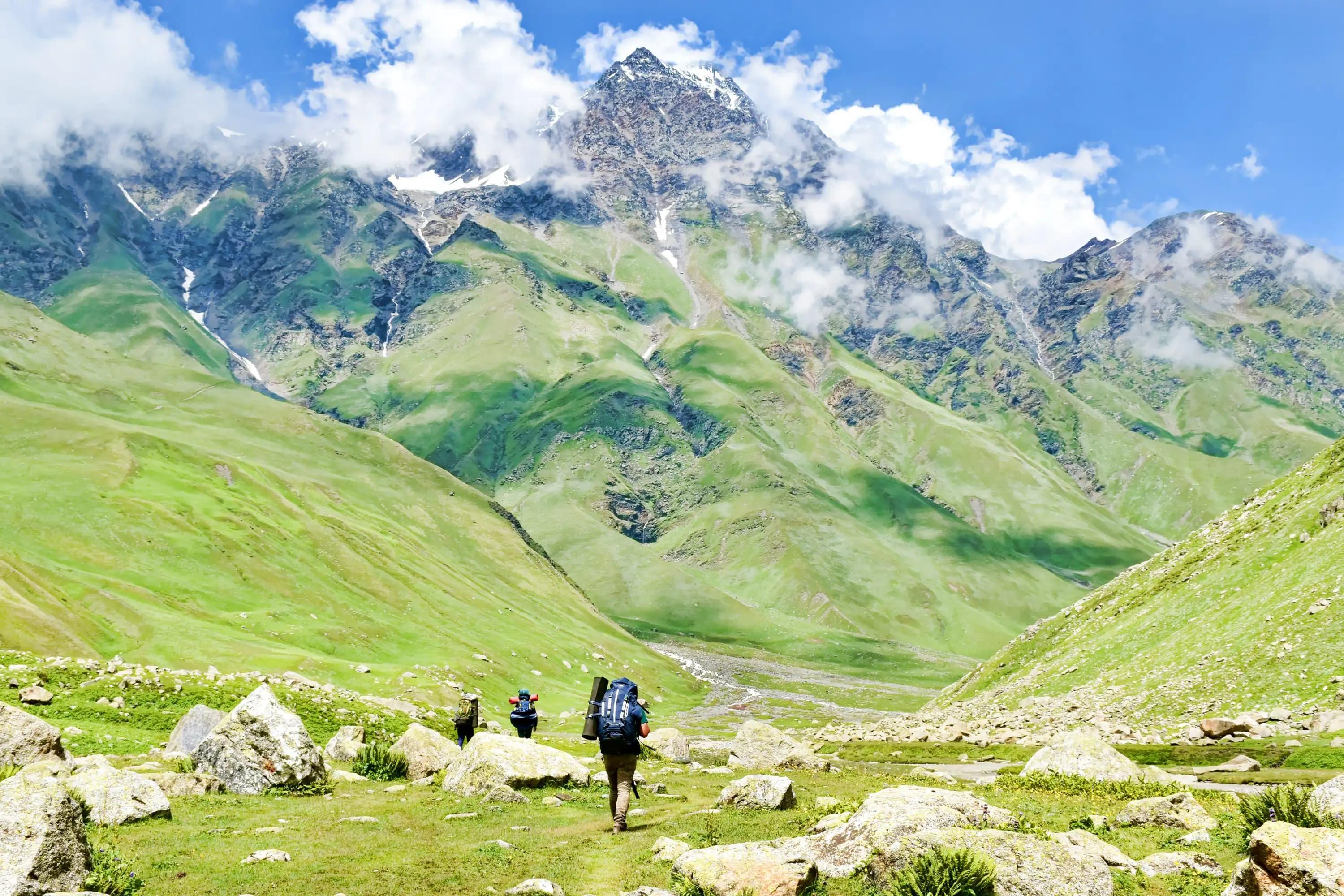
Friendship Peak (locally known as Dost Parvat) rises above the Solang Valley, just north of Manali in the Kullu district of Himachal Pradesh. At 5,289 metres, it sits on the ridge separating the Solang Nala from the Beas Kund basin — a landscape of glaciers, hanging seracs, and commanding panoramas that include the Dhauladhar range, the Pir Panjal, and on clear days, the distant white line of the Zanskar peaks.
It has earned its reputation as India's most popular introductory mountaineering objective — not because it is easy, but because it is the ideal proving ground. The route involves glacier travel, crampon work, fixed rope sections, and a summit push that demands both technical skill and high-altitude endurance. For thousands of Indian mountaineers, Friendship Peak was the summit where they first stood above 5,000 metres on a technical peak and understood what the mountains were truly asking of them.
Yunam Peak stands at 5,670 metres on the Lahaul-Spiti plateau, accessible from Sarchu on the Manali-Leh Highway — or via the Baralacha La region. It is a very different animal. Where Friendship Peak rewards glacier craft, Yunam is primarily a high-altitude endurance and scramble objective. The approach is itself an acclimatisation exercise in the high-altitude desert, the ascent is largely on scree, loose rock, and snow slopes, and the summit delivers perhaps the most jaw-dropping panorama of any beginner peak in northern India — with views stretching across the Zanskar, Lahaul, and Ladakh ranges.
Yunam is less glaciated than Friendship Peak, which makes it simultaneously more accessible to trekkers without technical training and more demanding in terms of raw altitude. The thin air at 5,670 m is unforgiving regardless of terrain — and Yunam's height makes it a serious acclimatisation and altitude-management challenge.
| Feature | Friendship Peak | Yunam Peak |
|---|---|---|
| Summit Altitude | 5,289 m | 5,670 m |
| Base Camp Altitude | ~3,900–4,100 m | ~4,800–5,000 m |
| Duration | 7–9 days | 6–8 days |
| Difficulty | Moderate–Difficult (Technical) | Moderate (Non-Technical) |
| Technical Skills Required | Yes — crampon, ice axe, rope | Minimal — basic scrambling |
| Glacier Travel | Yes — significant | No |
| Fixed Ropes on Route | Yes (summit section) | No |
| Altitude Challenge | Moderate | High |
| Best Season | May–June, September–October | July–September |
| Base Town | Manali | Manali / Sarchu |
| Route Character | Glaciated alpine | High-altitude desert scree/snow |
| Permit Required | Yes (IMF/State) | Yes (IMF/State) |
| Guides/Agency | Mandatory | Mandatory |
| Physical Demand | High | Moderate–High |
| Technical Demand | High | Low–Moderate |
| Success Rate (average) | ~65–75% | ~75–85% |
| Ideal For | First technical summit | First high-altitude summit |
| Crowd Level | Moderate–High | Low–Moderate |
Day 1 — Arrival in Manali (2,050 m) Acclimatise in Manali. Equipment check, briefing with your agency, gear fitting. Explore Old Manali to get your legs moving.
Day 2 — Manali → Dhundi / Solang Nala (2,480 m) Short drive to the Solang Valley trailhead. An easy walk through meadows and pine forest with Rohtang massif visible ahead.
Day 3 — Dhundi → Beas Kund (3,650 m) A well-worn trail that climbs steadily along the Solang Nala stream. Beas Kund — the sacred glacial lake at the source of the Beas River — is a landmark of the route. Camp above the lake.
Day 4 — Beas Kund → Base Camp (4,100 m) Moving upvalley into the glaciated basin below Friendship Peak. The terrain becomes more rocky and the views more expansive. Base camp is typically established below the main glacier.
Day 5 — Acclimatisation Day / Skills Training This is where your expedition becomes a mountaineering course. Crampon technique, ice axe arrest, rope team travel, and communication protocols are drilled on a suitable snow slope near base camp. This day distinguishes Friendship Peak from pure trekking objectives.
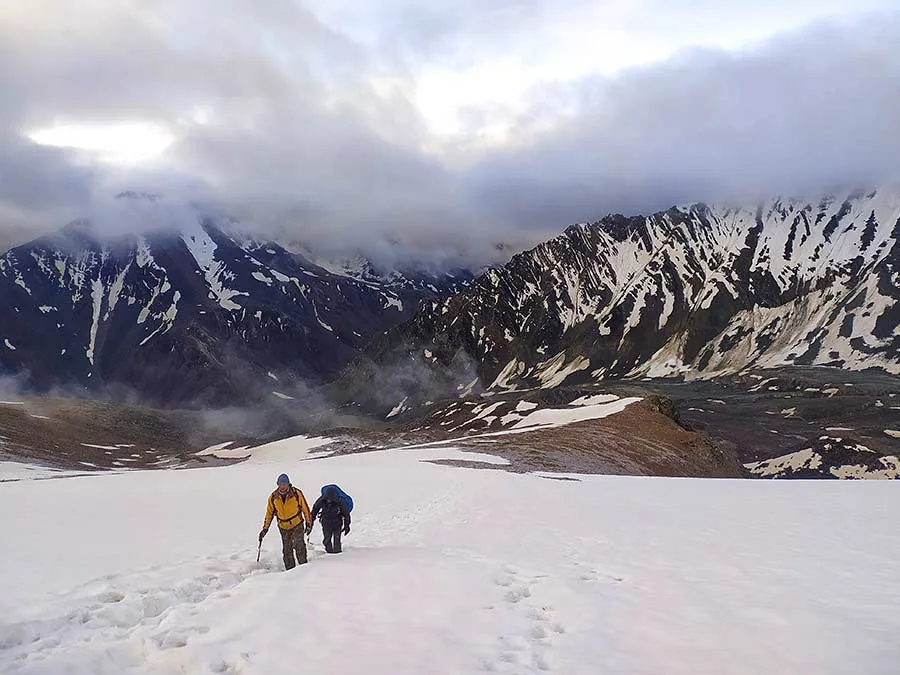
Day 6 — Base Camp → Advance Camp / High Camp (4,800–5,000 m) Moving up the glacier with full expedition packs. The route crosses the main icefall section and establishes camp on a snow platform below the final ridge.
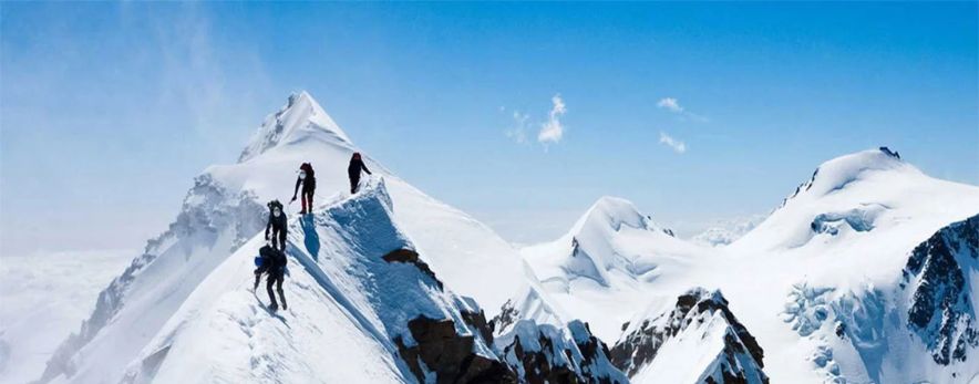
Day 7 — Summit Day: High Camp → Friendship Peak Summit (5,289 m) → Base Camp Pre-dawn start (typically 2–3 AM). Crampons and harnesses on in the dark. The summit ridge involves a steep snow/ice section where fixed ropes may be deployed. The summit view — stretching from the Pir Panjal in the south to the Zanskar range in the north — rewards every metre of the ascent. Descent to base camp the same day.
Day 8 — Base Camp → Manali Trek down and vehicle return to Manali. Celebration dinner well deserved.
Day 1 — Arrival in Manali (2,050 m) Rest and acclimatise. Equipment briefing with agency.
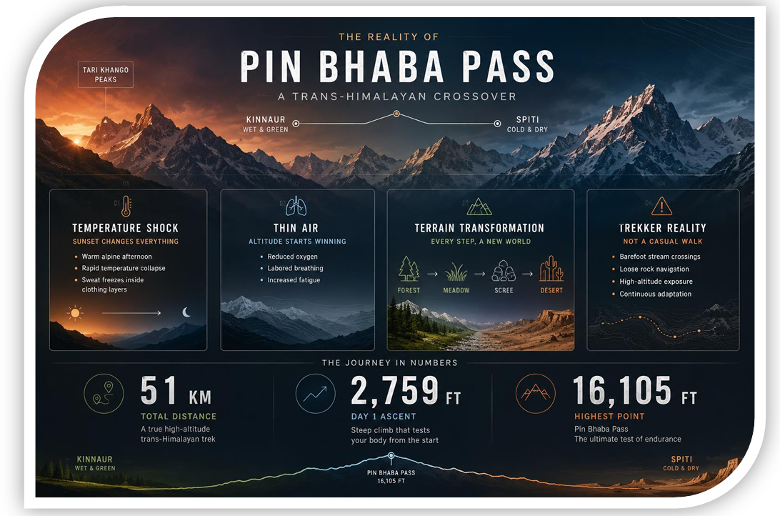
Day 2 — Manali → Sarchu (4,253 m) via Rohtang and Baralacha La A long but spectacular drive on the Manali-Leh Highway, crossing two high passes. Sarchu is a tent city of highway travellers — your first night at serious altitude.
Day 3 — Sarchu → Base Camp near Yunam (4,800–5,000 m) A short drive and walk to the base camp area on the Lahaul plateau. The landscape here is raw Himalayan desert — brown, vast, and vertiginous. The altitude at base camp itself exceeds Friendship Peak's summit.
Day 4 — Acclimatisation Day Short walks to gain altitude and test body response. Many expeditions include a day hike to ~5,200 m for acclimatisation.
Day 5 — Base Camp → High Camp (5,200–5,300 m) Establishing camp closer to the summit. The terrain is predominantly loose scree and consolidated snow. Navigation is straightforward; the challenge is purely altitude.
Day 6 — Summit Day: High Camp → Yunam Summit (5,670 m) → Descent An early alpine start, typically 4–5 AM. The summit push covers approximately 400–470 metres of altitude gain in thin air. The final section may involve a short steep snow slope but no technical rope work under normal conditions. The summit panorama encompasses the Baralacha La, Zanskar range, Lahaul peaks, and on clear days, distant Ladakh massifs.
Day 7 — Return to Manali Drive back via the Manali-Leh Highway.
This is the single most important factor in choosing between the two peaks — and it is often misunderstood.
Friendship Peak is technical. This word carries specific meaning in mountaineering: the route involves hazards and terrain features that require specialised equipment and trained techniques to navigate safely.
Specifically:
Glacier travel — The route crosses an active glacier with potential for crevasses. Roped travel is standard and non-negotiable. Your guide will determine rope team configuration and spacing.
Crampon technique — Metal crampons on ice and hard snow are essential. Improper crampon use on steep terrain is a leading cause of accidents on glaciated peaks. Your skills day at base camp is not a formality.
Ice axe use — Self-arrest technique (using the ice axe to stop a fall on steep snow) must be understood before the summit push. It is simple to learn but critical to internalise.
Fixed ropes — The steepest sections of the summit ridge typically have fixed ropes deployed by the lead guide. Proper ascending/descending technique with a jumar (ascender) or figure-8 is required.
Serac awareness — Sections of the route pass below hanging ice formations. Timing and route choice are guided by the lead mountaineer; understanding why matters.
If you have never used crampons or an ice axe, you will learn on Day 5 of the expedition. If you are uncomfortable learning technical skills quickly in high-altitude conditions, reconsider your timeline — not your objective.
Yunam Peak is non-technical in the mountaineering sense. The standard route does not require ropes, crampons (though microspikes or crampons may be useful on the final snow section), or glacier travel. It is, in essence, a very high and very demanding mountain walk.
What it does require:
Altitude management — At 5,670 m, Yunam sits 381 metres higher than Friendship Peak's summit. The difference between 5,289 m and 5,670 m in terms of oxygen availability and physiological stress is significant. Many trekkers who have performed well on 5,000 m objectives find the final push to Yunam's summit unexpectedly hard.
Scree and loose rock technique — The ascent involves long sections of loose, unconsolidated scree that demands careful footwork, patience, and energy conservation. It is physically demoralising terrain.
Cold and wind exposure — The Lahaul plateau is exposed to severe katabatic winds, particularly in the morning hours. Wind chill at summit altitude can push the effective temperature well below -20°C.
Navigation in low visibility — The open terrain, while visually simple, can become dangerously disorienting in cloud or snowfall. Guided travel is still essential.
You should be comfortable with:
Recommended pre-expedition training: 3 months of consistent aerobic conditioning (running, cycling, swimming), 2–3 multi-day treks at altitude above 3,500 m in the preceding year, and gym-based strength work for legs and core.
Similar overall fitness is required, but the emphasis shifts slightly:
The absence of technical demands does not make Yunam "easier" — it makes it differently demanding. Some mountaineers find pure altitude objectives harder than technical ones because there is no skill focus to occupy the mind through the discomfort.
The visual world of the Friendship Peak expedition is classically Himalayan alpine — a landscape familiar from photography and expedition accounts: white glaciers, bergschrunds, seracs, moraine, and the blue-green lake of Beas Kund at the valley's head. The forests of Solang Valley give a green, verdant approach before the terrain transitions to snow and ice.
The summit view is one of the finest in the western Himalaya — a 360-degree panorama that stretches from the gentler Dhauladhar ranges to the south to the jagged Zanskar peaks to the north, with the Kullu valley far below. Manali itself is visible on a clear day.
The Yunam landscape is altogether different. The Lahaul plateau on which it stands is a high-altitude desert — brown, ochre, sienna, and deep purple in the morning light. There are no trees, no grass, and very few people. The immensity of the plateau under a hard blue sky is vertiginous in a way that forested valleys rarely are.
The summit panorama from Yunam is arguably the more expansive of the two — the plateau's openness means the horizon extends in all directions to ranges that include the Zanskar, the Baralacha area peaks, and on exceptional days, hints of the Karakoram far to the north. It is a view that communicates geological time in a way that greener, more intimate landscapes cannot.
Primary season: May–June The pre-monsoon window offers stable weather, consolidated snow on the glacier (reducing crevasse hazard), and clear summit days. This is the peak season for Friendship Peak expeditions.
Secondary season: September–October Post-monsoon conditions offer excellent clarity and stable weather. Snow conditions vary more than the spring window and the nights turn cold earlier. A viable alternative for those who cannot travel in summer.
Monsoon (July–August): Not recommended. Rain, unstable snow, and increased rockfall hazard on the glacier.
Winter (November–April): Extreme cold, heavy snowpack, and avalanche risk make it suitable only for highly experienced high-altitude mountaineers.
Primary season: July–September The Manali-Leh Highway (which provides access to Sarchu) is typically open only from mid-June to October, making the monsoon window paradoxically the operating season for Yunam. Fortunately, the Lahaul plateau lies in the rain shadow of the Pir Panjal and receives very little monsoon precipitation — conditions are generally dry and stable.
May–June: Possible for those accessing Sarchu via helicopter or special convoy, but road access is typically restricted.
October: The highway begins closing due to snowfall. Late-season expeditions face increased risk of early winter conditions at the base camp altitude (~5,000 m).
Both peaks require permits from the Indian Mountaineering Foundation (IMF) and/or the Himachal Pradesh state mountaineering department. These are typically arranged by your agency as part of the expedition package.
Friendship Peak: Permit fees are relatively modest (in the range of ₹1,500–3,000 per person for Indian nationals; higher for foreign nationals). The route lies within the Kullu district and does not require an inner line permit. Liaison officer requirements should be confirmed with your agency at the time of booking.
Yunam Peak: Similar permit structure. The approach via Sarchu lies on the Manali-Leh Highway and the peak does not require restricted area permits under most current regulations. Verify with your agency, as Lahaul-Spiti regulations are subject to periodic revision.
Primary risks:
Accident history: Friendship Peak has seen fatalities, primarily related to falls on the technical section and, in some cases, inadequate guide qualifications. Choosing an agency with certified guides (Himalayan Mountaineering Institute or NIM graduates) is not optional.
Primary risks:
Accident history: Yunam has a lower reported accident rate due to its non-technical terrain. However, altitude-related evacuations are not uncommon among parties who have rushed acclimatisation.
Ideal pre-expedition curriculum:
6 months out: Begin aerobic base building — 4–5 days per week of running, cycling, or swimming. Target 45–60 minutes per session.
4 months out: Add pack hiking — day hikes and overnight trips with a 10–15 kg pack on uneven terrain.
3 months out: Altitude exposure — a 5–7 day Himalayan trek above 3,500 m (Hampta Pass, Beas Kund approach, Kedarkantha, Dayara Bugyal are appropriate objectives).
1 month out: Research crampon and ice axe fundamentals. Watch technique videos. Understand self-arrest, step-cutting, and front-pointing in principle before you practice in the field.
At the expedition: Trust your skills training day. Ask questions. Never proceed past your guide's comfort.
Similar aerobic preparation applies. Additionally:
Altitude pre-acclimatisation: If possible, spend 2–3 days in Manali or at 3,000+ m before departing for Sarchu. The jump from Manali (2,050 m) to Sarchu (4,253 m) in one day is a physiological stress — soften it where possible.
Psychological preparation: Prepare for the mental challenge of non-technical high-altitude grinding. Rest-step climbing on loose scree at 5,500 m with no technical focus to occupy the mind is harder than most people expect. Breathing rhythm, patience, and positive self-talk are skills worth developing.
The quality of your agency — and specifically your lead guide — is the single largest variable in your expedition's safety and success on either peak.
What to look for:
Reputable agencies to research: Himalayan Mountaineering Institute (runs its own Friendship Peak courses), Snow Leopard Adventures, Bikat Adventures, Trek the Himalayas, Indiahikes (selected expeditions), and several Manali-based agencies with verifiable track records.
Friendship Peak and Yunam Peak are not competing for the same climber. They are serving different needs at different stages of a mountaineering journey.
Friendship Peak is the beginning of technical mountaineering in India. If you summit it having learned its lessons — glacier movement, rope discipline, ice axe proficiency, and the mental framework of a summit day in the dark with crampons on your feet — you leave with a toolkit. You are no longer a trekker who went very high. You are a mountaineer.
Yunam Peak is the beginning of high-altitude ambition. If you summit it having managed your acclimatisation carefully, climbed patiently through thin air on unforgiving scree, and stood at 5,670 m with the entire Lahaul plateau spread out below you — you leave with an altitude reference point. You know what your body does above 5,500 m, and that knowledge is irreplaceable.
For many climbers, the ideal sequence is clear: Yunam first, to understand altitude. Friendship Peak next, to develop technique. And then the Himalaya proper — Stok Kangri, Kang Yatse, Mera Peak, and beyond — begins to open its doors.
But if you can only do one, here is the simplest possible guide:
If your gap is altitude experience → Yunam Peak.
If your gap is technical skills → Friendship Peak.
Fill your gap. The mountains will meet you where you are.
By air: Fly to Bhuntar Airport (KUU), Kullu — 50 km from Manali. Regular flights from Delhi. By road: Volvo/AC bus from Delhi to Manali (~14–16 hrs). HRTC and private operators available. By train: Nearest railhead is Chandigarh or Ambala → bus or taxi to Manali.
Drive on the Manali-Leh Highway via Rohtang Pass and Baralacha La. Road open approximately mid-June to early October. Duration: 7–9 hours depending on road conditions and convoy timing.