Yunam Peak is The Mountain That Made Mountaineers of Trekkers
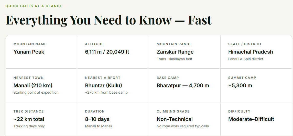
Yunam Peak stands at 6,111 metres above sea level in the Lahaul region of Himachal Pradesh, resting in the Zanskar Range of the Trans-Himalayas — the dry, cold, breathtaking terrain that lies north of the Great Himalayan chain. It is positioned just a few kilometres off the Manali–Leh Highway near the celebrated Baralacha La pass, placing it in one of the most scenically dramatic corridors in the Indian Himalayas.
For years, Stok Kangri in Ladakh held the crown as India's preferred first 6,000-metre summit. With that peak closed for conservation, Yunam has stepped into its role with distinction. It offers everything the aspiring high-altitude climber needs: a genuinely high summit, non-technical terrain, accessible logistics, and an honest physical challenge that separates it from a weekend trek.
The expedition typically begins and ends in Manali and spans 8–10 days including travel, acclimatization, and the summit push. The entire route is accessible by road, with no multi-day approach trek. This logistical accessibility — combined with a package cost within reach of the average Indian adventure traveller — makes Yunam a genuinely democratic 6,000-metre objective.
"There comes a time when trekking starts to feel familiar — the long days, the steady climbs. Yunam Peak is where that next step begins."
📍 Location: Lahaul, Himachal Pradesh — Zanskar Range
🏔 Summit: 6,111 m / 20,049 ft
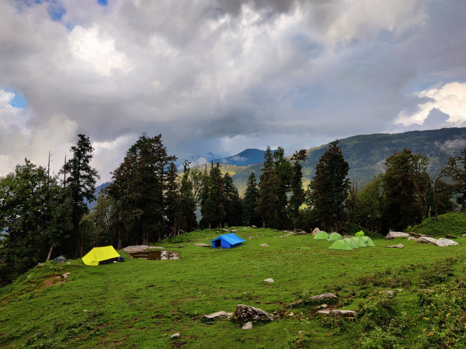
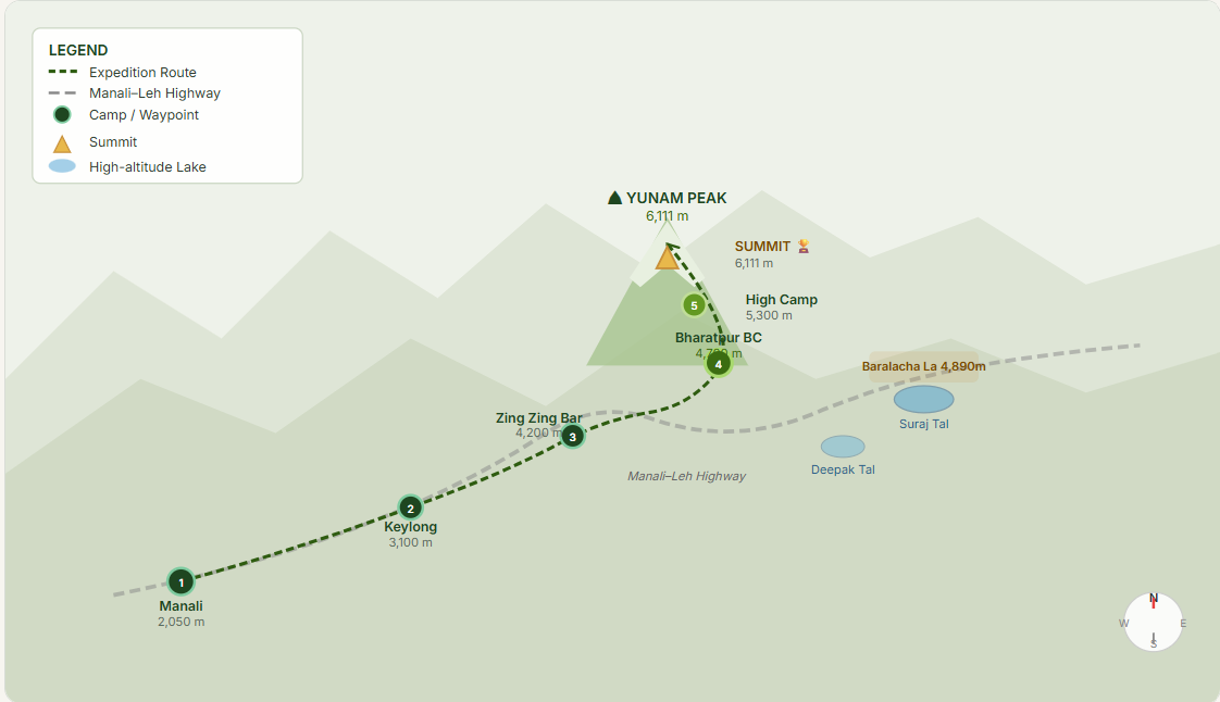
🚩 Base Camp: Bharatpur (4,700 m)
🏕 High Camp: Summit Camp (5,300 m)
🔵 Grade: Moderate–Difficult (Non-Technical)
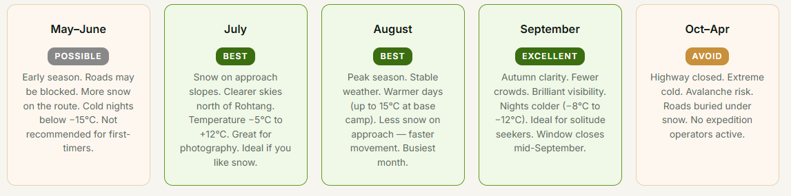
📅 Season: July to September
💰 Cost: ₹35,000 – ₹45,000 (all-inclusive)
🎯 Suitable for: Experienced trekkers, first 6K climbers
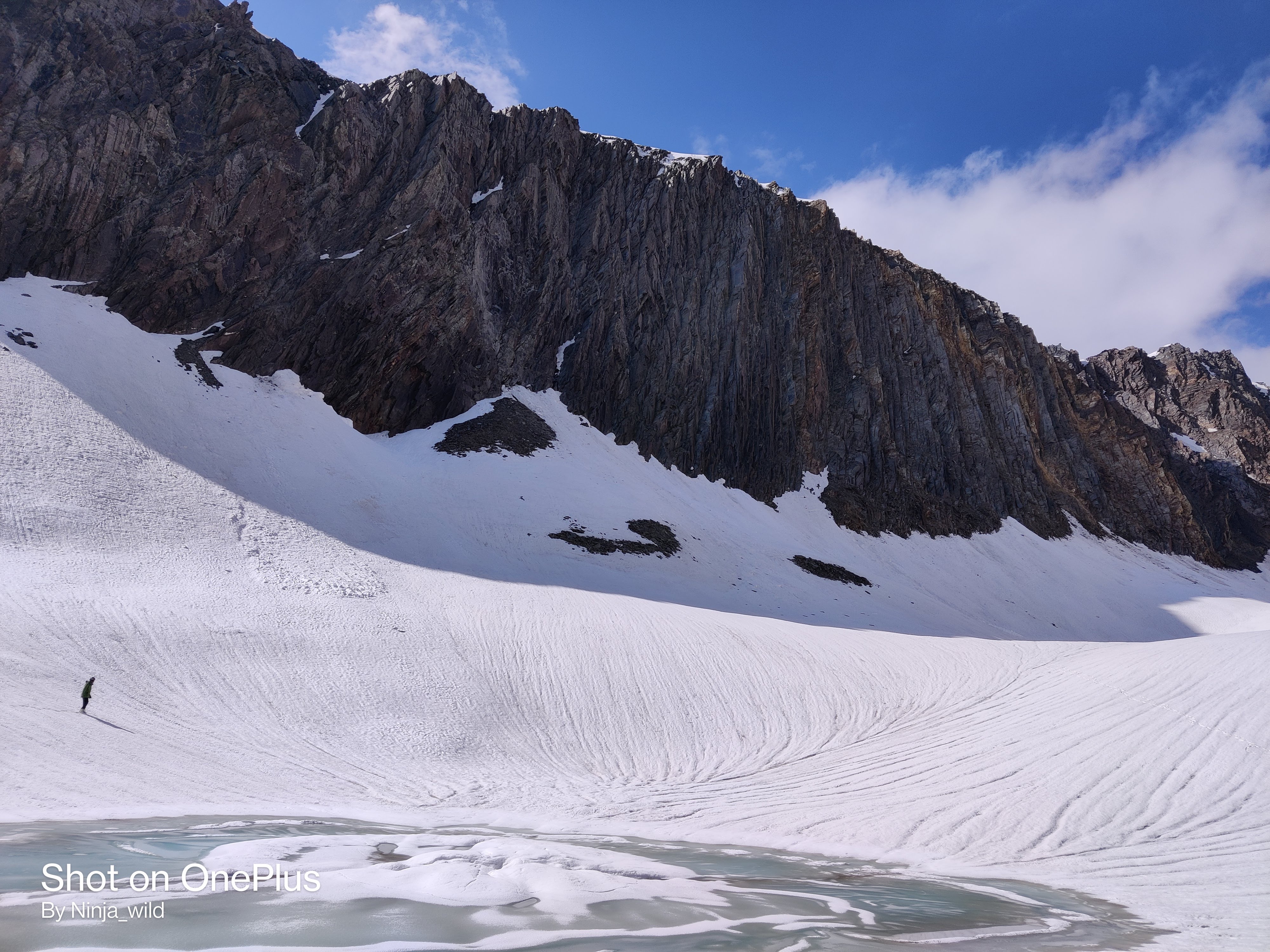
🌄360° Panoramic Summit Views: Standing on the summit offers sweeping views of the Chandrabhaga Range, Mulkilla peaks, Zanskar, and glimpses of Ladakh mountains on clear days.
🚀India's Premier Beginner 6K: After Stok Kangri's closure, Yunam has become the definitive first 6,000-metre summit for Indian mountaineers — non-technical, accessible, rewarding.
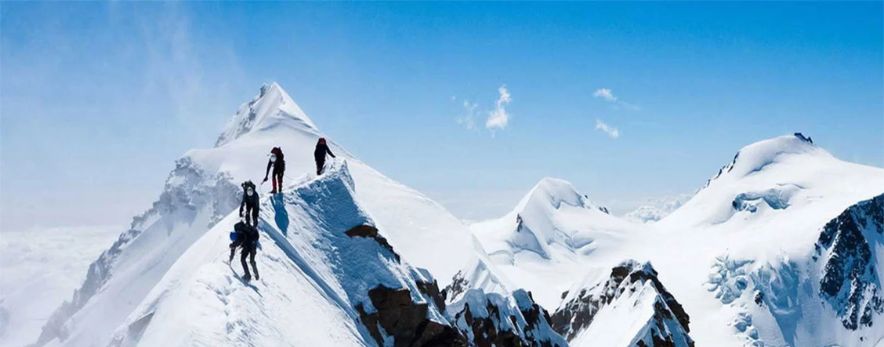
Summit by Starlight : The 2 AM summit push means you climb under the Milky Way, arriving at the top just as the horizon turns copper and gold with Himalayan sunrise.
💧Suraj Tal & Deepak Tal: Two of India's most pristine high-altitude lakes lie along the route — sapphire-blue Suraj Tal and the crystal-clear Deepak Tal where rocks are visible on the bed.
🦅Rare Wildlife Encounters: Bharal (blue sheep), red foxes, snow partridges, and Tibetan wild ass (kiang) inhabit the terrain, making every approach day an unexpected wildlife expedition.
🛤Road-Accessible Base Camp: Unlike remote Himalayan expeditions needing days of approach trek, Bharatpur base camp is reached directly by road — making logistics simpler and cheaper.
🏔Baralacha La Crossing: The route crosses the legendary Baralacha La at 4,890 m, a high mountain pass connecting Lahaul to Ladakh, with dramatic open skies and stark beauty.
🧘Off the Beaten Path: Compared to Stok Kangri or the Chadar trek, Yunam sees significantly fewer climbers — offering tranquillity, clean campsites, and an authentic mountain experience.
Geographical Overview A Mountain at the Crossroads of Ranges
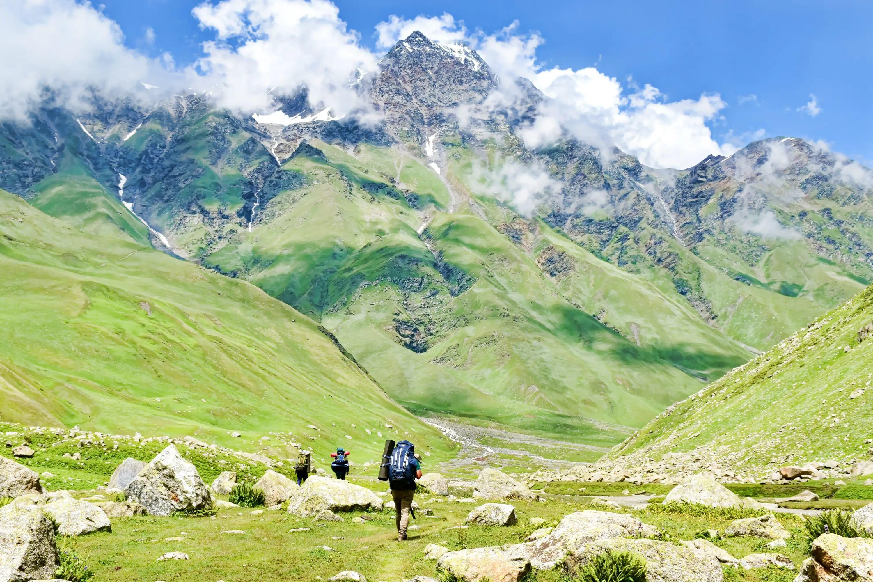
Yunam Peak Expedition occupies a fascinating geographical position. It sits in the Zanskar Range — a sub-range of the Trans-Himalayas — lying north of the Great Himalayan Range and south of the Ladakh Range. This places it in a dry, rain-shadow zone where the monsoon barely penetrates, creating a cold desert environment strikingly similar to Ladakh despite being in Himachal Pradesh.
The Manali–Leh highway, one of India's most spectacular mountain roads, passes just kilometres from the base camp. This highway marks the ancient trade corridor connecting the Lahaul and Spiti valleys to Ladakh and historically to Tibet. The Baralacha La pass (4,890 m), crossed en route to base camp, is the gateway between these worlds.
The terrain shifts dramatically as you travel north from Manali. Pine forests give way to scrub at Rohtang, then to bare moraine, scree, and glacial valleys beyond the Atal Tunnel. By the time you reach Bharatpur at 4,700 m, the landscape is pure Trans-Himalayan: brown, black, and white — rock, shadow, and snow.
Key Geographical Features
Mountain Range: Zanskar Range (Trans-Himalayan belt) — distinct from the main Himalayan chain. Geologically older, more arid, and less influenced by Indian Ocean monsoon.
Watershed Divide: Near the origins of the Chandra and Bhaga rivers, which merge at Tandi to form the Chenab. The Baralacha La is a triple watershed — source of rivers flowing to Indus, Chenab, and Yunan basins.
Climate Zone: Cold, arid trans-Himalayan climate. Annual rainfall below 350 mm. Strong UV radiation. Temperatures range from +15°C (July days) to −30°C (winter nights).
Elevation Profile: Manali (2,050 m) → Keylong (3,100 m) → Baralacha La (4,890 m) → Bharatpur (4,700 m) → High Camp (5,300 m) → Summit (6,111 m)
The Complete Expedition Route
The expedition follows the Manali–Leh highway northward before branching to Bharatpur base camp, then pushing into the mountain terrain above. Below is an annotated route map and day-by-day breakdown.
Acclimatization Curve How Your Body Adapts to the Altitude:
Acclimatization is the single most important factor determining summit success on Yunam Peak. The Yunam itinerary is carefully structured to follow the "climb high, sleep low" principle — ascending above target altitude during the day and returning to sleep lower. This stimulates red blood cell production without overwhelming the body.

Acclimatization Tips
- Climb high, sleep low — follow the itinerary exactly
- Drink 3–4 litres of water daily; avoid alcohol
- Eat even without appetite — caloric needs are high
- Take Diamox (acetazolamide) only after doctor consultation
- Move slowly on ascent days — "pole pole" (slowly, slowly)
- Sleep at the same or lower altitude than the day's high point
Flora & Fauna of the Region Life at the Roof of the World
Despite its barren appearance, the Lahaul-Zanskar region surrounding Yunam Peak harbours a surprising diversity of high-altitude life. Flora and fauna here have evolved extraordinary adaptations to survive extreme cold, UV radiation, thin air, and minimal rainfall. Every sighting on the approach is a privilege.
Flora — Plants That Survive at the Edge
Iconic Flora
Himalayan Blue Poppy Meconopsis aculeata — the ethereal blue flower, Himachal Pradesh's state flower, found in rocky crevices up to 4,500 m. Blooms June–August.
Alpine Plant Edelweiss Leontopodium himalayanum — the star-shaped white flower, beloved symbol of the high Alps and Himalayas, found on rocky slopes above 3,500 m.
Medicinal Herb Wild Thyme Thymus serpyllum — aromatic carpets of purple-flowered thyme cover the hillsides of Lahaul, used in local medicine and cooking.
Succulent Stonecrop (Sedum) Several Sedum species cling to rocky outcrops, their fleshy leaves retaining water in the arid trans-Himalayan environment.
Groundcover Alpine Cushion Plants Dense, round cushion-form plants hug the ground to minimize wind exposure and conserve heat — a remarkable cold-desert adaptation.
Cryptogam Rock Lichens Orange, grey, and black lichen patches cover boulders throughout the route, surviving where almost nothing else can — among the oldest living organisms on Earth.
Fauna — Animals of the High Himalayas
Most Seen Bharal (Blue Sheep) Pseudois nayaur — agile cliff-dwelling wild sheep with a grey-blue coat, often seen in herds on rocky slopes above 4,000 m. The most commonly spotted large mammal.
Predator Snow Leopard Panthera uncia — the ghost of the mountains. The Lahaul region has a significant population. Extremely rare to spot, but paw prints and scrapes appear on trail.
Canid Himalayan Red Fox Vulpes vulpes montana — often spotted near camps and on open hillsides, its distinctive russet coat bright against the grey scree. Curious and unafraid.
Bird Snow Partridge Lerwa lerwa — a chunky high-altitude gamebird with barred plumage, found on rocky slopes. Often heard before seen — a sharp whistle on the wind.
Rare Sighting Tibetan Wild Ass (Kiang) Equus kiang — the largest wild equid in the world. Occasionally seen near Baralacha La and on the Bharatpur plateau. A memorable encounter.
Raptor Himalayan Griffon Gyps himalayensis — massive vulture with a 2.8 m wingspan, soaring on thermals above the valleys. Spotting one circling overhead is a Himalayan signature experience.
Best Time to Visit The Yunam Weather Window
Yunam sits in a rain-shadow zone beyond Rohtang Pass. Unlike southern Himalayan peaks that are hammered by monsoon rain, the terrain here is dry and barren even in July and August. This makes Yunam one of the most weather-reliable 6,000-metre peaks in India.
Local Life & Cultural Insights The People and Traditions of Lahaul:
The Lahaul Valley has been inhabited for centuries by communities deeply shaped by Tibetan Buddhism, harsh climate, and the ancient trade routes that once connected India, Ladakh, and Tibet. Travelling through this region is as much a cultural journey as a physical one.
🏔The Lahauli People: Lahaul's population is primarily Lahauli — a mix of Indo-Aryan and Tibetan lineage. They speak Lahauli (Bunan), Tibetan dialects, and Hindi. Known for warmth, resilience, and a deep reverence for the mountains they call home.
🕌Buddhist Monasteries: The Keylong area has several significant gompas (monasteries) including Khardang Gompa and Shashur Monastery — visible from the highway. Built on cliffs, they house ancient thangkas and Buddhist relics. An afternoon visit on Day 2 is unforgettable.
🏘Jispa Village: A small, photogenic Lahauli village of under 300 people along the Bhaga River. Mud houses, prayer flags, rolling fields, and Buddhist shrines sit incongruously alongside modern highways and trekker lodges — a living crossroads of old and new.
🪔Tibetan Buddhism : Mani walls, prayer wheels, and strings of prayer flags line the route. The mountains are considered sacred in Tibetan cosmology. The local practice of "puja" before a summit attempt — seeking blessings from the mountain — reflects the spiritual dimension of Himalayan climbing.
🌾Traditional Agriculture: At lower altitudes in Lahaul, terraced fields produce barley, peas, and potatoes — crops adapted to the short growing season. The valley blooms briefly and brilliantly in summer, a counterpoint to the surrounding desolation.
🤝Responsible Tourism: Patronize local tea stalls and guesthouses in Keylong and Jispa. Buy local produce rather than imported packaged food. Respect monastery visiting customs — remove shoes, dress modestly, don't photograph without permission. Leave no trace in the mountains.
Fitness Requirements Level of Difficulty & Physical Preparation:
Yunam is non-technical — no prior rope work or ice climbing is required. But altitude is the great equalizer. At 6,111 metres, your body is operating with roughly 47% of the oxygen available at sea level. Fitness is what decides whether that feels manageable or catastrophic.
A minimum of 8–10 weeks of dedicated training is strongly recommended. Operators suggest being able to jog 10 km comfortably in under 60 minutes as a useful baseline fitness benchmark before joining an expedition.
Who Should Attempt Yunam
- Prior high-altitude trek experience (above 4,500 m) — Hampta Pass, Stok Kangri Base, Buran Ghati etc.
- Comfortable trekking 6–8 hours daily on steep, rocky terrain
- No history of severe AMS, heart, or lung conditions
- 8–10 weeks of structured fitness training completed
- No mountaineering certification required, but basic knowledge of crampons is helpfu

10-Week Training Blueprint
Weeks 1–3 Build base: run/walk 30–45 min, 4×/week. Add bodyweight squats, lunges, planks. Start stair climbing.
Weeks 4–6 Increase to 8–10 km runs. Add weekend hikes with a loaded daypack (8–10 kg). Introduce hill intervals.
Weeks 7–9 Long hikes of 15+ km. Back-to-back trekking days. Altitude exposure if possible (a pre-trip to Manali/Rohtang).
Week 10 Taper. Light runs only. No heavy exercise 5 days before departure. Focus on sleep, hydration, nutrition.
Safety & Emergency Guidelines Mountain Safety is Non-Negotiable
Yunam may be non-technical, but the Himalayas demand unconditional respect. Weather changes in minutes, altitude can incapacitate even fit climbers, and the nearest hospital is hours away. Understanding protocols before you go is as important as your physical training.
Before You Go
Full medical check-up including ECG and lung function. Consult a doctor about Diamox. Ensure all vaccinations are current. Share your itinerary with someone not on the expedition. Carry a copy of your IMF permit and emergency contacts.
AMS Management Protocol
Mild symptoms (headache, fatigue): rest, hydrate, take ibuprofen/paracetamol. Do NOT ascend further. Moderate (vomiting, loss of coordination): descend 300–500 m immediately. Severe (HACE/HAPE): treat with dexamethasone/nifedipine, descend NOW, activate emergency evacuation.
Emergency Contacts
Keylong District Hospital: nearest major facility. ITBP (Indo-Tibetan Border Police) has camps along Manali–Leh highway. Manali Mountain Rescue: +91-1902-252352. Ensure your operator has a satellite communication device or PLB (Personal Locator Beacon).
Absolute Turn-Around Rules
Turn around unconditionally if: a team member shows HACE or HAPE signs; visibility drops to zero; temperature falls dangerously below forecast; you are not at the summit by 10 AM. No summit is worth your life. Yunam will be there next year.
Gear Safety Essentials
Headlamp + spare batteries (summit starts at 2 AM). Emergency foil blanket. First aid kit with Diamox, dexamethasone, ibuprofen, blister pads. Trekking poles (mandatory). Micro-spikes or crampons. Sun protection: SPF 50+, glacier goggles, balaclava.
Weather Watch
Check forecasts with your guide the night before summit day. Avoid ascent if wind speeds above 40 km/h or precipitation forecast. Lightning risk is extreme on ridges — descend immediately if thunderstorm approaches. Yunam weather windows change fast.
How to Get Your Permit Yunam Peak Expedition — Permit Guide
Yunam Peak, standing above 6,000 m, requires a permit from the Indian Mountaineering Foundation (IMF) — the apex national body for mountaineering in India. Most reputable expedition operators handle this on your behalf, but understanding the process ensures you are not caught unprepared.
Good news for 2026: The IMF's online permit portal makes applications significantly easier than in the past. Most organized tour operators (registered with IMF) include permit processing in their expedition fee. If you're doing an independent expedition, follow the steps below directly.