Complete Warwan Valley Adventure Guide
Complete Warwan Valley Adventure Guide
26
May

The Warwan Valley Trek moves through one of the most remote and visually raw mountain regions in Kashmir — a route where the landscape still feels shaped more by rivers, glaciers, weather, and isolation than by trekking tourism.
The trail crosses deep valleys, glacier-fed rivers, pine forests, alpine meadows, moraine terrain, hanging villages, and enormous mountain corridors that continue changing character for days at a time. Unlike many Himalayan routes where camps and trails remain constantly active during the season, large sections of Warwan feel almost motionless once the deeper valley stretches begin.
The scale of the landscape changes slowly but continuously.
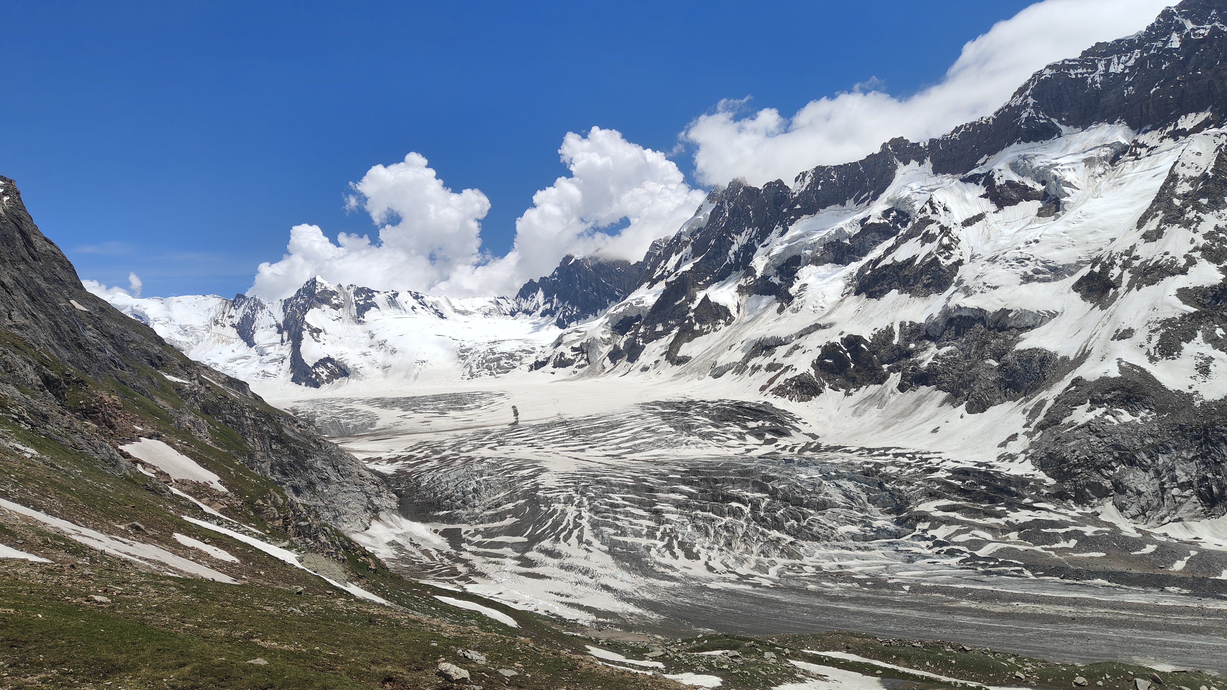
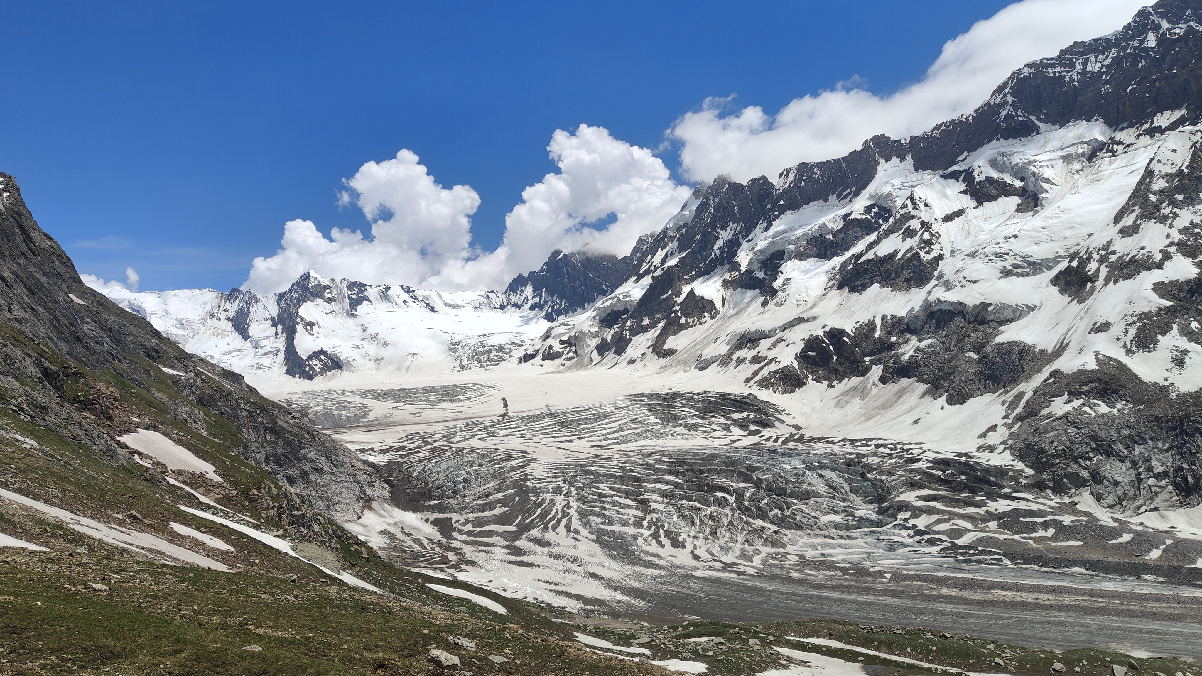
Lower valleys begin greener and quieter with riverside trails, grazing routes, wooden settlements, and forest sections shaped by seasonal mountain life. Higher sections gradually become colder, rougher, and more glacial as the terrain opens into exposed valleys surrounded by loose rock, snow patches, and distant ridgelines holding weather far above the trail.
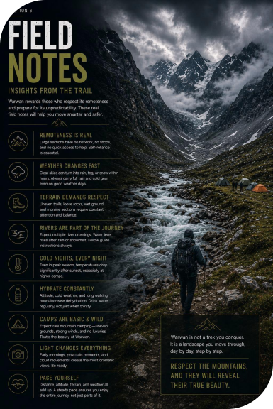
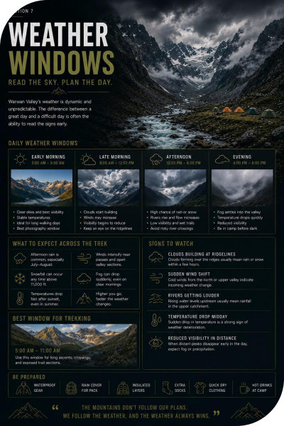
Some mornings begin with completely clear skies and sharp mountain visibility. Then clouds begin gathering near the ridges, rivers grow louder after rainfall, and entire sections of the valley slowly disappear beneath shifting fog and colder wind.
Warwan rarely feels polished.
That is part of what makes it memorable.
The trek itself is not technically extreme for experienced trekkers, but the physical effort compounds steadily through:
• long walking distances,
• uneven terrain,
• altitude gain,
• river crossings,
• cold camps,
• and repeated exposure to changing mountain weather.
Several sections feel less like a trekking route and more like moving through an active mountain corridor where the environment constantly reshapes the experience around you.
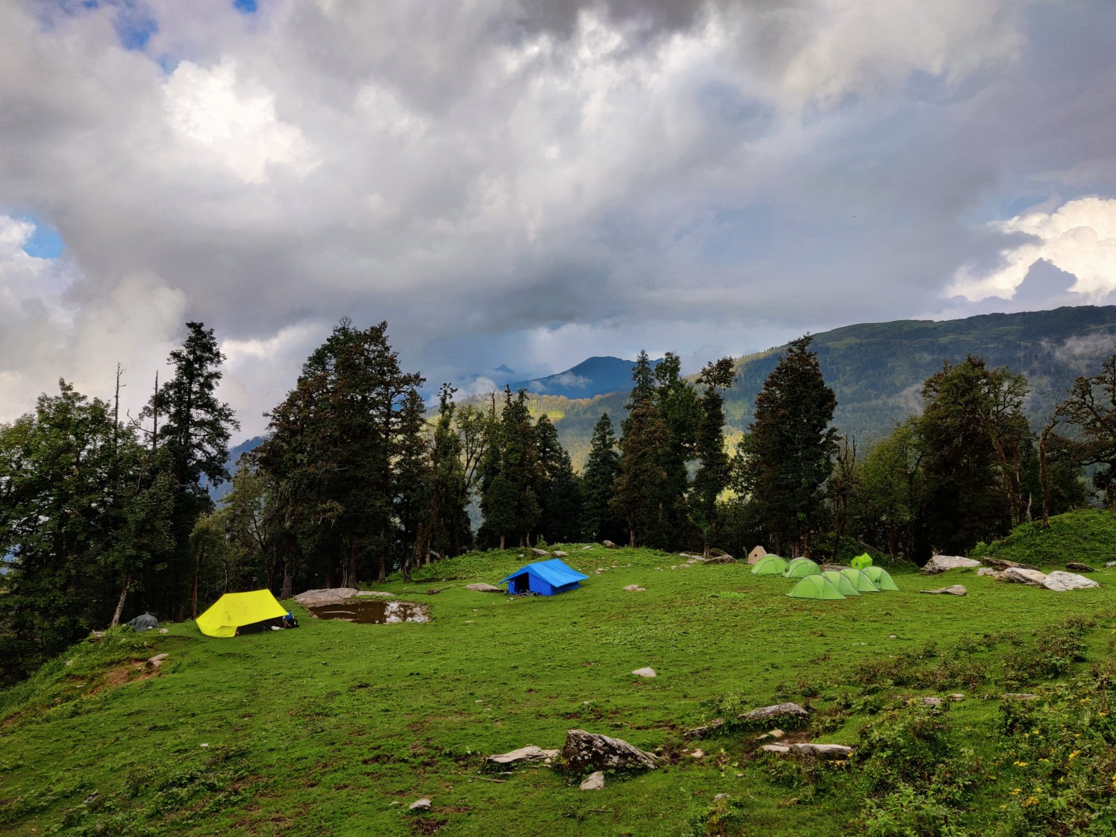
Some evenings near the higher camps feel completely detached from normal life — just rivers moving through the valley, cold wind crossing the grasslands, and distant ridgelines slowly fading into darkness after sunset.
Warwan does not feel dramatic in one single moment.
It feels wilder the deeper you move into it.
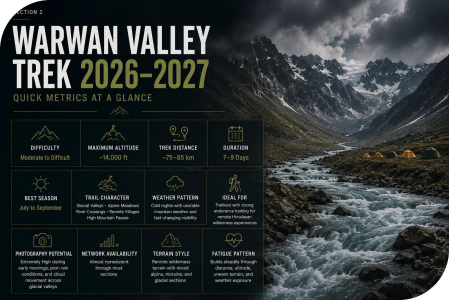
Difficulty- Moderate to Difficult
Maximum Altitude- 14,000 ft
Trek Distance- 75–85 km
Duration- 7–9 Days
Best Season- July to September
Trail Character- Glacial Valleys • Alpine Meadows • River Crossings • Remote Villages • High Mountain Passes
Weather Pattern- Cold nights with unstable mountain weather and fast-changing visibility
Ideal For- Trekkers with strong endurance looking for remote Himalayan wilderness experiences
Photography Potential- Extremely High during early mornings, post-rain conditions, and cloud movement across glacial valleys
Network Availability- Almost nonexistent through mostsections
Terrain Style- Remote wilderness terrain with mixed alpine, moraine, and glacial sections
Fatigue Pattern- Builds steadily through distance, altitude, uneven terrain, and weather exposure
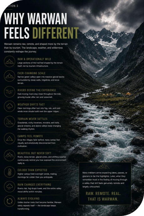
• Unlike heavily commercialized Himalayan routes, Warwan still feels
operationally raw across large sections of the valley. Many camps and trail systems feelshaped more by the terrain itself than by tourism infrastructure. • The scale of the landscape changes constantly. Narrow green valleys gradually open into enormous glacial basins surrounded by steep mountain walls,
exposed ridgelines, and distant snow-covered terrain.
• Rivers dominate the atmosphere of the trek. The sound of fast-moving water remains present near many camps and walking sections, especially after rainfall or afternoon snowmelt.
• Weather shifts quickly inside the valley. Clear mornings often transition into fog, rain, and colder wind movement once clouds begin building near the upper ridges.
• The route rarely settles into one terrain pattern for long. Grasslands, rocky traverses, moraine sections, wet trails, glacial streams, and alpine valleys continuously reshape the walking rhythm throughout the expedition.
• Several campsites feel visually disconnected from civilization once the village sections disappear behind the trail. Some evenings pass with almost no visible movement anywhere across the valley.
• Even though Warwan contains beautiful meadow systems, the landscape rarely feels soft or relaxed for very long. Rivers, loose terrain, changing weather, and glacial sections constantly remind trekkers how exposed the environment actually is.
• Mornings near the higher camps often feel significantly colder than expected because the valleys hold overnight wind movement long after sunrise reaches the surrounding peaks.
• Rain changes the valley almost immediately. Rivers become louder, fog settles lower into the terrain, and darker skies begin reshaping the mood of the landscape within minutes.
• Unlike shorter scenic treks where the environment begins feeling familiar after a few days, Warwan keeps changing continuously. The terrain rarely repeats itself long enough for the route to feel predictable.
• Many trekkers arrive expecting the lakes, passes, or glacier sections to become the strongest memories of the trek. Later, what they often remember most isthe feeling of moving through a valley that still feels genuinely remote and largely untouched by constant outside activity.
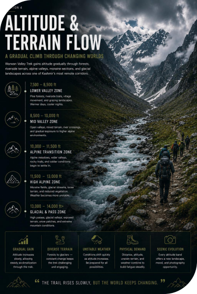
The Warwan Valley Trek gains altitude gradually through forests, riverside terrain, alpine valleys, moraine sections, and glacial landscapes spread across one of Kashmir’s most remote mountain corridors.
The lower sections usually feel greener and more protected with pine forests, village movement, grazing terrain, and riverside trails shaping the landscape. As the trek progresses, the valleys become colder, wider, and increasingly glacial once the higher alpine sections begin appearing across the route.
The terrain constantly changes through the expedition:
• grasslands,
• rocky sections,
• moraine terrain,
• wet trail systems,
• glacial streams,
• exposed alpine valleys,
• and uneven river crossings.
This keeps the route visually immersive, but it also quietly increases physical fatigue because walking rhythm rarely remains consistent for very long.
Some sections allow steady movement for hours.
Others slow the pace almost immediately through loose rock, damp terrain, unstable footing, or repeated stream crossings.
Weather strongly affectsthe experience here.
Rainfall changes river conditions quickly, wet rocks reduce movement confidence, and afternoon fog can suddenly hide entire valley systems that looked completely open earlier in the day.
Altitude usually becomes more noticeable after repeated nights inside the colder upper camps where thinner air, lower temperatures, and reduced recovery gradually begin affecting energy levels across longer walking days.
Warwan rarely feels artificially structured.The landscape itself keeps reshaping how the trek feels from one valley section to the next.
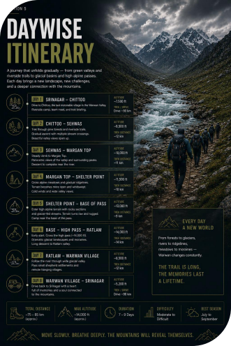
The drive from Srinagar toward Panikhar gradually leaves behind the greener Kashmir valleys and enters colder mountain terrain shaped by rivers, exposed ridgelines, glacier-fed water systems, and high-altitude roads crossing through the Suru region.
After Zoji La, the landscape begins feeling noticeably harsher and more open.
• Drive Duration: ~8–10 hours
• Base Camp Altitude: ~10,500 ft
• Trail Character: High mountain roads, river valleys, exposed terrain
The drive itself becomes physically tiring for many trekkers because the altitude gain happens relatively quickly during the transition toward Panikhar.
Evening light near the Suru Valley often creates sharp contrast across barren ridges, glacier-fed rivers, and the surrounding mountain walls.
The trek begins gradually through riverside valleys and open meadow sections where the scale of the surrounding mountains becomes immediately noticeable.
Glacial streams, shepherd movement, and grazing routes shape much of the lower terrain during the first walking day.
• Distance Covered: ~10–11 km
• Trek Duration: ~5–6 hours
• Highest Altitude: ~11,000 ft
• Trail Character: Meadows, riverside trails, gradual ascent
The terrain initially feels comfortable, but constant exposure and long walking distances quietly drain more energy than many trekkers expect during the early days.
Morning movement through the greener valley sections usually provides softer lighting before cloud build-up begins later in the afternoon.
The route gradually moves deeper into the valley where forests begin thinning and larger alpine terrain starts dominating the landscape.
Rivers grow louder, camps feel more isolated, and surrounding ridgelines begin appearing significantly steeper and colder than the lower sections from earlier days.
• Distance Covered: ~11–12 km
• Trek Duration: ~6–7 hours
• Highest Altitude: ~12,000 ft
• Camp Altitude: ~11,800 ft
• Trail Character: Alpine valleys, rocky sections, glacial rivers
Weather exposure becomes noticeably stronger from this stage onward, especially once cold wind begins moving through the open valley systems.
Post-rain conditions near Kalapari often create dramatic low-cloud movement beneath the surrounding peaks.
This section introduces rougher alpine terrain where the valley gradually narrows toward colder glacial landscapes and higher mountain walls.
Trail surfaces become more uneven and walking rhythm slows because of moraine sections, loose rock, and exposed terrain spread across the valley floor.
• Distance Covered: ~10–11 km
• Trek Duration: ~6–7 hours
• Highest Altitude: ~13,000 ft
• Trail Character: Moraine terrain, alpine valleys, exposed trails
The route rarely feels brutally steep, but rough terrain and colder weather quietly increase exhaustion over time.
Cloud shadows moving across the upper valley usually create the strongest landscape contrast during late afternoon conditions.
This becomes one of the physically hardest and visually largest days of the trek asthe route crosses exposed high-altitude terrain near Kaintal Pass before descending toward the Warwan side of the valley system.
The landscape changes dramatically here.
The greener lower valleys disappear behind the trail and the environment beginsfeeling colder, rougher, and significantly more glacial.
• Distance Covered: ~13–14 km
• Trek Duration: ~7–9 hours
• Highest Altitude: ~14,000 ft
• Trail Character: High-pass crossing, glacial terrain, rocky descents
Thin air, colder wind, and long exposed walking sections slow movement significantly near the pass, especially during unstable weather conditions.
Clear mornings near Kaintal Pass usually provide the widest mountain visibility before clouds begin covering the upper ridges later in the day.
Warwan feels different from many Himalayan routes because the valley still retains a strong sense of unpredictability and isolation through large sections of the expedition.
The camps feel farther apart. Terrain changes more aggressively. Villages gradually disappear behind the trail until entire stretches of the valley pass with almost no signs of roads or outside movement.
Even during trekking season, several camps remain completely quiet after sunset except for rivers moving through the valley or wind crossing the open terrain.
The remoteness slowly becomes physical.
Not just visual.
After multiple days inside the valley, many trekkers begin noticing how unusual it feels to spend hours without traffic noise, mobile networks, crowded trails, or constant movement around them.
Water shapesthe atmosphere of Warwan almost continuously.
Glacial rivers remain present near many walking sections and camps throughout the route, especially after rainfall or afternoon snowmelt when water flow becomes stronger across the valley.
Some sections feel calm during the morning, then noticeably louder by evening once weather conditions shift higher in the mountains.
The sound itself changes too.
Narrow streams near meadow sections eventually become wider and more forceful near glacial terrain where rivers begin dominating the landscape visually as well as acoustically.
Several trekkers later remember the sound of moving water as strongly as the mountain views themselves.
Warwan rarely exhauststrekkersthrough one steep climb.
Instead, fatigue buildsthrough constantly changing terrain that interrupts walking rhythm throughout the expedition.
The route repeatedly shifts between:
• moraine sections,
• damp trails,
• river crossings,
• loose rock,
• alpine meadows,
• and uneven glacial terrain.
Some stretches allow smooth movement for long periods.
Then the trailsuddenly slowsthrough unstable footing or rougher sections where every step requires more balance and attention than earlier in the day.
This constant adjustment gradually drains energy more than many trekkers initially expect.
Especially after multiple consecutive walking days.
Afternoons can feel surprisingly warm while moving through lower valley sections.
Then weather changes quickly once the trail enters the colder alpine corridors near Kaintal and the higher camps.
Open glacial terrain allows wind to move freely across the valley systems, especially after sunset once temperatures begin dropping and physical movement slows near camp.
Cold here rarely feels dramatic at first.
It arrives gradually through:
• damp gloves,
• reduced movement,
• colder wind exposure,
• and long eveningsinside open terrain farfrom shelter.
Many trekkers feel comfortable while walking, then suddenly begin searching for warmer layers and hot food soon after reaching camp.
Weather movementreshapes Warwan continuously.
Valleys that feel wide and sharply visible during the morning often become partially hidden beneath cloud systems by afternoon once fog begins moving lower through the ridgelines.
The atmosphere changes almost immediately after rainfall.
Rivers become louder. Mountain walls darken. Visibility compresses across the valley. Distant terrain that looked close earlier in the day suddenly begins feeling isolated once clouds settle deeper into the landscape.
Some mornings near the upper camps feel almost unreal in their clarity. Then within an hour, the weather changes completely.
Warwan rarely allows the landscape to stay visually stable for long.
One of the deceptive parts of Warwan is how manageable the trek initially feels during the lower sections.
The exhaustion usually becomes noticeable later once:
• colder camps,
• altitude,
• rough terrain,
• and repeated long walking days
begin combining together.
The body gradually recovers slower after multiple nights inside exposed alpine terrain. Trekkers often notice this most during mornings.
Simple things like putting on cold shoes, leaving sleeping bags, or starting the first climb of the day begin feeling heavier compared to the earlier stages of the expedition.
July gives Warwan its freshest and most dramatic appearance of the season.
The lower valleys remain intensely green while the higher terrain often still holds lingering snow patches near the glacial sections and exposed ridges. Cloud systems move constantly across the valley during this month, making the landscape feel different almost every few hours.
• Deep green lower valleys
• Active weather systems
• Lingering snow patches
• Strong river flow
• Frequent cloud movement
• Fewer trekkers compared to peak season
Wild, colder, and highly atmospheric.
Several mornings begin with completely clear visibility before fog and rainfall gradually reshape the valley later in the day.
August — Most Stable Trekking Conditions
The meadows remain fully green, glacial streams become more manageable, and weather windows generally stay more stable compared to July.
Thisis also when the valley feels most alive with shepherd movement, grazing activity, and clearer morning visibility across the alpine terrain.
• Stable trekking conditions
• Peak greenery
• Better visibility windows
• Clearer photography conditions
• More balanced river crossings
• Peak trekking season
Expansive, immersive, and visually fullest.
The combination of greener valleys, calmer mornings, and clearer mountain visibility usually makes August the most comfortable month for long multi-day movement through the valley.
September slowly changes the mood of Warwan.
The grasslands begin turning softer and more golden while mornings and nights become significantly colder across the higher camps.
Once monsoon moisture begins reducing, visibility becomes much sharper across the glacial terrain and surrounding ridgelines.
• Golden alpine terrain
• Sharper mountain visibility
• Cleaner photography conditions
• Colder mornings and nights
• Reduced crowd density
• Quieter campsites
Colder, quieter, and more isolated.
Several trekkers prefer September because the valley begins feeling slower and more remote once the peak trekking movement starts fading.
Best Months - July to September
Typical Day Temperature - 8°C–18°C
Typical Night Temperature- -2°C–5°C
Remote Himalayan trekking, glacial landscapes, alpine valleys, wilderness photography, long-distance trekking, and immersive multi-day mountain expeditions.
Warwan is not technically extreme for experienced trekkers, but the route becomes physically demanding because of:
• long distances,
• rough terrain,
• repeated altitude gain,
• river crossings,
• and exposure to changing mountain weather.
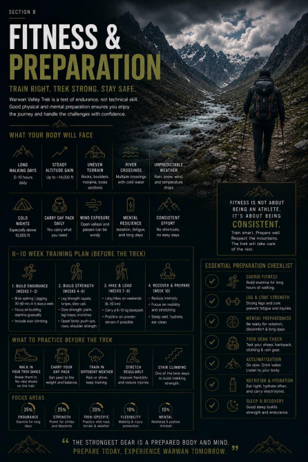
Preparation should focus more on endurance, walking stamina, and recovery than aggressive gym strength alone.
Trekkers usually adapt far more comfortably if they are already capable of:
• walking long distances consistently,
• climbing steadily without frequent long breaks,
• carrying moderate backpack weight,
• and recovering properly after consecutive active days.
The valley often looks visually manageable in photographs.
The physical reality feels very different after multiple days inside glacial terrain and exposed alpine sections.
Warwan is usually better suited for trekkers who already have prior multi-day trekking experience.
Strong beginners with proper preparation can complete the route, butthey still need to handle:
• rough terrain,
• colder camps,
• long walking days,
• altitude exposure,
• and changing weather conditions over consecutive days.
Trekkers without prior endurance-based hiking experience usually struggle much more once the higher valley sections begin.
You are usually in a comfortable range for Warwan if you can:
• walk 12–14 km steadily,
• recover properly the next morning,
• climb stairs continuously for 50–60 minutes,
• and maintain controlled breathing during long gradual ascents. Consistency matters much more than aggressive speed here.
Trekkers who push too aggressively during the early days often begin slowing down significantly once rough terrain, altitude, and colder camps start affecting recovery quality.
Warwan rewards-controlled pacing.
Not rushing.
Several experienced trekkers move slower than expected during the first half of the expedition specifically to conserve energy for the longer glacial sections later in the route.
Warwan punishes poor gear systems more consistently than softer meadow-based treks.
The route regularly exposestrekkersto:
• damp terrain,
• colder camps,
• rough moraine sections,
• unstable weather,
• and long walking daysfar from settlements.
Small comfort mistakes slowly compound over time once recovery quality begins reducing inside the valley.
River crossings, wet trails, glacial streams, and damp terrain remain common across large sections of the route.
Even light rainfall changes footing conditions quickly because rocks, moraine terrain, and trail surfaces hold moisture for long periods.
Most trekkers begin feeling noticeably slower once:
• shoes remain wet,
• socks stop drying properly,
• or cold moisture exposure continues over consecutive days.
Reliable waterproofing improves comfort significantly during the later sections of the expedition.
Cold mornings and warmer valley sections create inconsistent layering conditions through the trek.
Trekkers who overdress early while climbing often begin sweating heavily, which later becomes uncomfortable once wind exposure increases near the glacial terrain and higher camps.
The most comfortable trekkers usually:
• adjust layers gradually,
• avoid overheating during movement,
• and keep one completely dry camp layer reserved for evenings.
Dry clothes after sunset change recovery quality more than most trekkers initially expect.
Warwan rarely feels technically dangerous under normal conditions, but uneven terrain continuously stresses feet and ankles throughout the expedition.
Moraine sections, damp ground, loose rock, and repeated long descents gradually begin affecting walking comfort after multiple days.
Reliable trekking shoes with:
• strong grip,
• ankle support,
• and waterproofing
usually improve movement confidence significantly across rougher sections of the valley.
People commonly carry:
• extra casual clothing,
• unnecessary electronics,
• oversized jackets,
• and backup items they rarely use.
At the same time, they underestimate:
• socks,
• layering systems,
• rain protection,
• gloves,
• electrolyte support,
• and moisture management.
Warwan usually rewards lighter and more functional packing systems over excessive gear weight.
Usually, the smallest things improve the experience the most:
• dry socks before sleep,
• insulated gloves,
• waterproof backpack covers,
• lip balm,
• electrolyte support,
• and protecting electronics from cold moisture exposure.
Cold damp gear slowly affects morale much faster than many trekkers initially expect.
1. Is Warwan Valley Trek difficult?
Warwan is usually considered a moderate to difficult Himalayan trek.
The route is not heavily technical under normal conditions, but long distances, rough terrain, altitude, river crossings, and changing weather make it physically demanding.
2. Can beginners do the Warwan Valley Trek?
Strong beginners with proper preparation can complete the trek, although prior multi day trekking experience helps significantly.
The route becomes much harder for people without endurance-based hiking exposure.
3. What makes Warwan physically tiring?
Usually not one single climb.
Most trekkers feel exhausted because of:
• long walking days,
• rough terrain,
• altitude,
• weather exposure,
• river crossings,
• and slower recovery after repeated camps.
4. Is Warwan steeper than Kashmir Great Lakes?
Warwan generally feels rougher and more physically demanding because of its terrain variety, remoteness, and glacial sections.
KGL usually feels more structured and predictable by comparison.
5. What is the highest altitude of the trek?
The highest sections usually reach around 14,000 ft near Kaintal Pass.
6. Doesthe trek involve glacier terrain?
Yes.
Several sections pass through moraine terrain, glacial valleys, and exposed alpine areas influenced heavily by surrounding glacier systems.
7. Are river crossings common?
Yes.
Glacial streams and river crossings remain present through several sections of the route, especially after rainfall or afternoon snowmelt.
8. How cold doesit get at night?
Night temperatures near the higher camps can drop below freezing, especially during July and September.
Wind exposure across open valleys often makes conditions feel colder after sunset.
9. Which is the best month for Warwan Valley Trek?
August is usually considered the most balanced month because of:
• more stable weather,
• greener valleys,
• clearer visibility,
• and more manageable trail conditions.
10. Does weather change quickly in Warwan?
Very quickly.
Clear mornings often shift into fog, rain, and colder wind movement by afternoon once cloud systems begin building across the valley.
11. What kind of terrain does the trek have?
The route includes:
• alpine valleys,
• glacial rivers,
• moraine terrain,
• rocky trails,
• meadow sections,
• exposed mountain passes,
• and river crossings.
12. Isthe trek crowded?
Compared to commercial Himalayan trekking routes, Warwan usually feels significantly quieter and more isolated throughout the season.
13. Are trekking poles useful here?
Very.
They help significantly during moraine sections, river crossings, uneven terrain, and long descents.
14. Doesfog affect visibility often?
Yes.
Cloud movement frequently changes visibility inside the valley, especially during afternoons and unstable weather conditions.
15. How fit should I be for Warwan?
Trekkers should ideally feel comfortable:
• walking 12–14 km,
• climbing steadily for long durations,
• and recovering properly after consecutive active days.
16. Is gym training enough for preparation?
Not entirely.
Endurance, walking stamina, and recovery capacity matter far more than gym strength alone during long multi-day Himalayan treks.
17. Why do people underestimate Warwan?
Because photographs often fail to show:
• the scale of the valley,
• terrain roughness,
• weather exposure,
• and how physically tiring the remoteness itself becomes after multiple days.
18. How important is pacing here?
Extremely important.
Trekkers who maintain controlled pacing usually recover much better across the expedition compared to people who push aggressively during the early days.
19. What isthe hardestsection of the trek?
The Kaintal Pass section usually feels physically hardest because of altitude, exposure, rough terrain, and long movement through glacial landscapes.
20. What do most trekkers remember after finishing Warwan?
Usually the remoteness, enormous valleys, moving rivers, changing weather, glacial landscapes, and the feeling of spending multiple days inside terrain that still feels genuinely wild and largely untouched.