29
Jun

🏔
The Valley of Glaciers
Lahaul • Himachal Pradesh • 3,000 m – 4,900 m
|
📅 Duration 7 Days |
⛰️ Max Altitude ~4,900 m |
🥾 Difficulty Moderate-Hard |
📍 Region Lahaul, HP |
🌊 Glaciers 21+ Glaciers |
🌤️ Best Season Jul–Sep |
Nestled in the remote Lahaul region of Himachal Pradesh, Miyar Valley is one of the most scenic Himalayan valleys, often called the "Valley of Flowers of Himachal." The trek is famous for alpine meadows, granite peaks, glacial rivers, rare blue poppies, and the spectacular Kesar Yon Chhap (Seven Sacred Lakes). The standard trek covers approximately 60–65 km over 7 days and reaches an altitude of around 4,000–4,050 m (13,120–13,290 ft).Tucked between the Zanskar Range and the Kullu Himalaya in Himachal Pradesh's Lahaul district, the Miyar Valley (also written as Miyar Nullah) is one of the least-explored and most pristine valley systems in the Indian Himalaya. It stretches roughly 60 kilometres from the Miyar Nullah confluence near Udaipur town to the snout of the Miyar Glacier, one of the longest glaciers in Himachal Pradesh, before ascending further to the high Kang La pass that connects it to the Zanskar Valley in Ladakh.
The valley has been inhabited for centuries by communities of the Lahauli people, an ethnically Tibetan-influenced group who settled these high valleys as traders, herders, and farmers. The villages along the Miyar — Urgos, Khanjar, Thaur, Shukto, and the larger Urgos hamlets — were historically stops on the ancient Lahaul–Zanskar trade route, a high-altitude corridor that predates modern roads by many centuries. Salt, wool, grain, and ritual objects moved across the Kang La and neighbouring passes, linking the Buddhist communities of Lahaul with the monasteries and villages of Zanskar.
British surveyors mapped the Miyar Valley during the Great Trigonometrical Survey of India in the 19th century. Survey expeditions under officers like Henry Haversham Godwin-Austen recorded the glaciers and passes of the region, recognising the Miyar Glacier as one of the major ice bodies of the western Himalaya. The name 'Miyar' itself is believed to derive from the Tibetan 'Mi-yar' — a term local lore associates with the ancient families who first settled the valley's high pastures.
Mountaineering interest in the Miyar Valley grew in the mid-20th century when climbers began accessing the peaks surrounding the glacier. The cluster of 6,000–6,500 m peaks visible from the Miyar Glacier — including Menthosa (6,443 m), Takdung (6,100 m), CB-13, Neverseen Tower, and Tharang (6,096 m) — attracted small expeditions through the 1970s, 80s, and 90s. However, unlike the better-known valleys of Kullu or Kangra, Miyar remained largely off the mainstream trekking circuit, earning a devoted following among serious trekkers and alpinists who valued its solitude.
The construction of the Keylong–Udaipur road in the 1990s improved access to the valley's lower reaches, but the interior remains roadless. Today, Miyar Valley is listed among India's great 'offbeat' treks — a place where villages of whitewashed stone houses cluster below enormous glaciers, where blue sheep graze above 4,500 m, and where you may walk for days without meeting another trekker. Its 21+ tributory glaciers feeding from the high cirques make it one of the most glacier-dense valley systems accessible to trekkers in India.
2. Key Highlights of Miyar Valley Trek
No trek in the Indian Himalaya offers quite this combination — remote, geologically spectacular, culturally intact, and ecologically rich. Here is what makes Miyar Valley unforgettable.
|
🏔 21+ Tributary Glaciers The Miyar Glacier and its tributaries form one of the most extensive glaciated systems accessible to trekkers in Himachal Pradesh. Walking beside — and at times on — these rivers of ancient ice is the defining experience of the trek. |
🌿 Untouched Wilderness Unlike Hampta Pass or Pin Parvati, Miyar Valley sees fewer than 500 trekkers per season. Campsites are pristine, wildlife is unhabituated, and the sense of genuine exploration is palpable — especially above the Miyar Glacier. |
|
🏘️ Living Buddhist Villages Villages like Urgos, Khanjar, and Shukto are extraordinary time capsules — stone-and-mud homes with Buddhist prayer flags, chortens (stupas) at every entrance, and gompas (monasteries) clinging to cliff faces above the valley. Locals still live a semi-nomadic pastoral life. |
🦅 Rich High-Altitude Wildlife Himalayan Blue Sheep (Bharal), Golden Eagle, Lammergeier (Bearded Vulture), Himalayan Snowcock, and — if you are extraordinarily lucky — Snow Leopard. The upper valley is prime snow leopard habitat. |
|
⛰️ Kang La Pass (Optional) For those with mountaineering experience, the Kang La (5,468 m) connects Miyar Valley to the Zanskar Valley in Ladakh — one of the most spectacular and demanding high passes in the western Himalaya. |
🌸 Wildflowers and Alpine Meadows July brings carpets of Himalayan blue poppy, edelweiss, potentilla, and gentian across the high pastures. The contrast of vivid colour against grey moraines and white glaciers is strikingly beautiful. |
✦ Dramatic geological formations: The valley cuts through ancient Himalayan crystalline basement rock, exposing striking bands of marble, gneiss, and schist. Neverseen Tower — a 500 m granite spire — is one of the most iconic rock features in all of Himachal Pradesh
✦ Absence of crowd: On most days above Khanjar, you may be the only trekking team in the entire valley
✦ Cross-valley option to Zanskar: The Kang La crossing makes this a complete traverse from Lahaul to Ladakh
✦ Clear, dark-sky nights: No light pollution for many hours in any direction — among the best stargazing in India
✦ Photography: Ice pinnacles (penitentes) on the Miyar Glacier, reflected peaks in meltwater pools, eagle flight — extraordinary frames at every turn
3. Quick Itinerary — At a Glance
| Day | Route | Distance | Time |
|---|---|---|---|
| Day 1 | Manali → Khanjar (Drive) | 140 km | 5–6 hrs |
| Day 2 | Khanjar → Yolling | 9 km | 5 hrs |
| Day 3 | Yolling → Zardong | 12 km | 6 hrs |
| Day 4 | Zardong → Kesar Yon Chhap → Palpu | 12–13 km | 7 hrs |
| Day 5 | Palpu → Gompa → Yolling | 16–17 km | 7 hrs |
| Day 6 | Yolling → Khanjar | 10 km | 5 hrs |
| Day 7 | Khanjar → Manali | 140 km Drive | 5–6 hrs |
4. Things We Love About the Miyar Valley Trek
After many treks across the Indian Himalaya, the Miyar Valley holds a special place. Here is what keeps calling us back — and what we think you will love most.
❶ The Glaciers Feel Personal
On the Gangotri Glacier or the Zemu Glacier, you are one of thousands in a season. On the Miyar Glacier, you may have the entire 15-km expanse to yourself. The tributary glaciers — Takdung, Tharang, Ibex — each have their own character: one ends in a wall of seracs, another in a perfect bowl of blue ice. You can spend hours exploring and never encounter another party.
❷ The Villages Are Living History
Khanjar and Urgos are not tourist villages. There are no tea shops with laminated menus, no porters competing for your attention. What there is: local families who may invite you in for butter tea and tsampa if you pause long enough; dogs sleeping in the sun by chortens a thousand years old; children walking to school along the same path their great-grandparents used. These interactions are quiet and unhurried, and they stay with you long after the mountains have faded.
❸ Neverseen Tower Will Stop You in Your Tracks
Roughly a day's walk above the glacier snout, a 500+ metre granite monolith rises vertically from the valley floor. The name was given by the first climbers to document it — and it fits. From a distance, it looks like someone placed an enormous cathedral spire in the wilderness. Framed against the glacier, at golden hour, it is one of the most extraordinary sights in Himalayan trekking.
❹ Wildlife That Hasn't Learned to Fear
Blue sheep here graze 50 metres from where you sit eating lunch. They glance at you with curiosity but no alarm — a sign that hunting pressure in the valley is low. Golden Eagles patrol the ridgelines. Early mornings, Himalayan Snowcock call from impossibly high scree fields. On our best mornings here, we have watched Lammergeier (Bearded Vultures) soaring at eye level across the glacier — an experience that is genuinely humbling.
❺ The Silence
In the upper valley, there is no traffic noise, no music, no announcement, no crowd murmur. What there is: the groan of a glacier shifting in the night; the thin whistle of wind across a serrated ridge; the trickle of a meltwater stream. This is the kind of silence that is actually full — not empty but made of a thousand small sounds you never normally hear. Trekkers often describe it as the most profound quiet they have ever experienced.
❻ Every Camp is Different
From the lush green camping ground at Shukto — surrounded by willows and wild roses — to the stark moonscape of the moraines at Camp II, each night's camp is a completely different environment. By Day 7, you will have slept in a forest, a village meadow, a river gorge, a glacial moraine, and a high cirque. Few treks in India offer this range of landscape in a single route.
❼ Stars Like You Have Never Seen
At 4,300 m, on a moonless July night, the Milky Way is not a smear — it is a three-dimensional river of light with visible structure and depth. Lying outside your tent on the Miyar Glacier moraine, watching shooting stars cross the glaciated peaks, is one of those experiences that makes the aching legs and the freeze-dried food completely, absolutely worth it.
5. Best Time to Visit Miyar Valley
Miyar Valley is a high-altitude trans-Himalayan valley in the rain-shadow zone of Lahaul. Unlike the wetter Kullu or Kinnaur valleys, it receives very limited monsoon precipitation, making it one of the rare trekking destinations in the Indian Himalaya that is accessible and enjoyable during the summer monsoon months.
|
Month |
Season |
Conditions |
Verdict |
|
Jun |
Late Spring |
Road opens (Jun); snow on upper trail |
Possible but glacier snow is deep; only for experienced teams |
|
Jul |
Summer Peak |
Rain-shadow; green meadows; wildflowers |
✦ EXCELLENT — Best wildflower display |
|
Aug |
Summer |
Warm days; minimal precipitation; stable |
✦ EXCELLENT — Ideal conditions overall |
|
Sep |
Early Autumn |
Cool; clear skies; glacier in best state |
✦ EXCELLENT — Peak visibility, firm glacier |
|
Oct |
Autumn |
Cold nights; early snow possible above 4k |
GOOD — Early October only; road closes Oct–Nov |
|
Nov–May |
Winter/Spring |
Valley snowbound; road closed |
NOT RECOMMENDED — Extreme cold, no access |
Window Comparison: July vs August vs September
|
Factor |
July |
August |
September |
|
Wildflowers |
★★★★★ Peak bloom |
★★★★☆ Late bloom |
★★☆☆☆ Fading |
|
Glacier access |
Soft snow; easier walking |
Firm conditions |
★★★★★ Best — hardest ice |
|
Temperature (day) |
10–18°C at camp |
8–16°C at camp |
4–12°C at camp |
|
Night temperature |
-2 to 5°C |
-4 to 3°C |
-8 to -2°C |
|
River crossings |
High water; tricky |
Moderate |
Low; safest |
|
Crowd level |
Minimal |
Minimal |
Lowest of all |
|
Photography |
Green + ice |
Best balance |
Autumn gold + peaks |
|
🌼 Our Recommendation Go in late July for the wildflowers and green valley. Go in late August for the perfect balance of warmth, stable weather, and glacier access. Go in September if you want the most dramatic sky, the clearest peaks, and the hardest glacier ice for crossing — but pack a proper sleeping bag rated to -15°C. |
6. How Difficult Is the Miyar Valley Trek?
|
Overall Rating: Moderate to Difficult Best suited to trekkers with prior Himalayan experience (4,000–4,500 m). Not a first-timer trek. |
What Makes It Moderate?
✦ The approach through the valley (Days 2–4) is a straightforward river-valley walk with no technical terrain
✦ Total daily distances (9–14 km) are manageable for a reasonably fit trekker
✦ No technical climbing required on the standard route (without Kang La crossing)
✦ The altitude is high but the gain is gradual — no single day exceeds 700 m of altitude gain
✦ The trail above glacier Base Camp is well-cairned during peak season (July–September)
What Makes It Difficult?
✦ Glacier travel on days 5–7 requires experience: moraines are unstable, crevasses exist, and there is no waymarked trail on the ice
✦ Maximum camp altitude of 4,600–4,900 m means real altitude sickness risk — proper acclimatisation is mandatory
✦ River crossings in July can be knee to thigh-deep, and at certain points the current is significant
✦ The remoteness is real — the nearest road is 3–5 days' walking behind you in the upper valley. Helicopter landing zones are limited
✦ Camping is on rough terrain (moraine boulders, scree) above the glacier — tent pitching can be challenging
✦ Weather can change rapidly — afternoon thunderstorms are possible in July–August
✦ No teahouses, no mobile network above Udaipur, no medical facilities closer than Keylong (150+ km)
Difficulty Breakdown by Day
|
Day |
Difficulty |
Rating |
Primary Challenge |
|
1 |
Easy |
★☆☆☆☆ |
Long drive; altitude gain manageable |
|
2 |
Easy–Mod |
★★☆☆☆ |
First river crossings; uneven path |
|
3 |
Moderate |
★★☆☆☆ |
Longer day; trail narrows into gorge |
|
4 |
Moderate |
★★★☆☆ |
More elevation gain; river crossings increase |
|
5 |
Mod–Hard |
★★★☆☆ |
Moraine walking; first AMS risk zone |
|
6 |
Hard |
★★★★☆ |
Glacier travel; unstable boulders; altitude |
|
7 |
Hard |
★★★★☆ |
High altitude exposure; technical moraine |
|
8 |
Mod–Hard |
★★★☆☆ |
Rest/explore; Kang La approach if chosen |
|
9 |
Mod–Hard |
★★★☆☆ |
Long descent; knee stress; Kang La: Very Hard |
|
10 |
Easy |
★☆☆☆☆ |
Valley walk out; road access restored |
Are You Ready? — Fitness Self-Check
✦ You should be comfortable walking 8–12 km per day for 6–8 consecutive days with a 10–12 kg pack
✦ Prior experience on at least one trek above 3,500 m is strongly recommended
✦ You should have no history of severe AMS and should not have had a recent respiratory or cardiac illness
✦ You should be able to walk on uneven, boulder-strewn terrain for extended periods
✦ Train: 3 months of preparation — regular hiking (once a week, 600–800 m gain), cardio (running 5 km 3×/week), core strength
7. How Each Day Looks on the Miyar Valley Trek
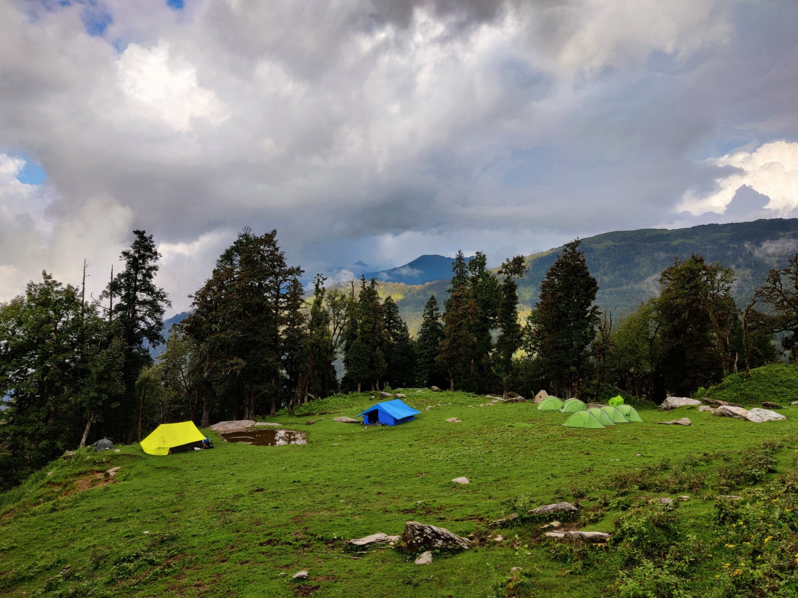
Begin your journey from Manali and cross the impressive Atal Tunnel, entering the rugged landscapes of Lahaul. Drive through Keylong and Udaipur before entering the beautiful Miyar Valley. Reach Khanjar village, complete campsite briefing, and enjoy your first evening beneath towering Himalayan peaks.
Highlights
The trek begins gently through green meadows and shepherd settlements. You'll walk beside the crystal-clear Miyar River with panoramic views of snow-covered mountains.
Highlights
Today's trail gradually enters the heart of Miyar Valley. Massive granite walls, glacial streams, and wide-open landscapes dominate the scenery.
Highlights
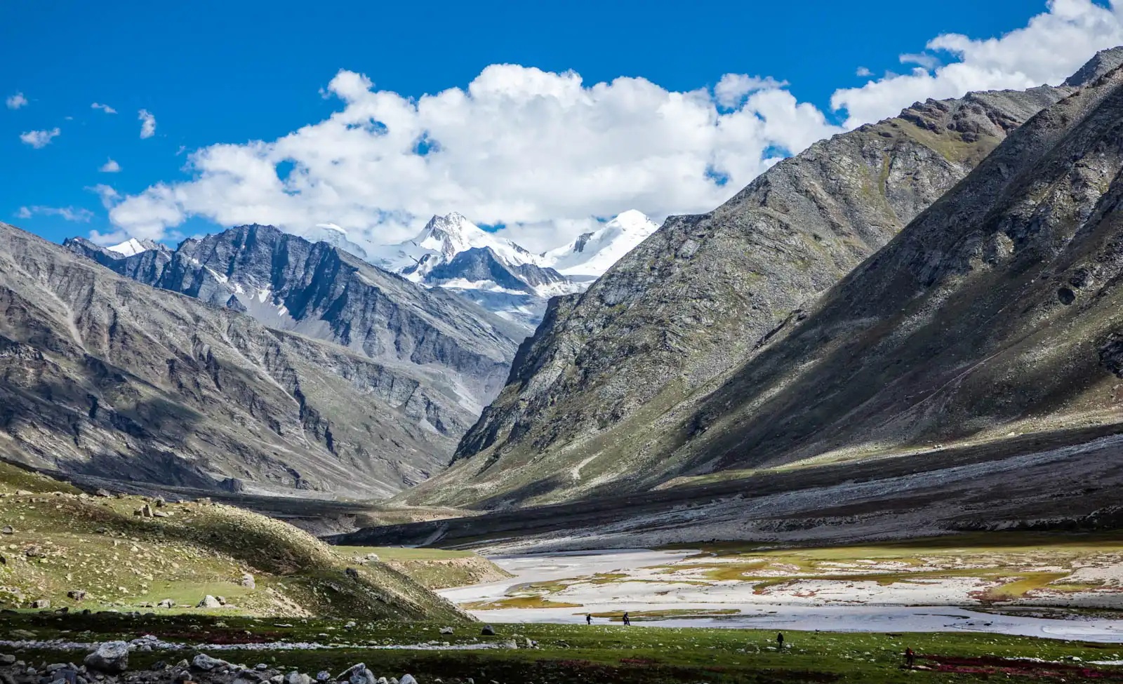
This is the most spectacular day of the trek. Reach Kesar Yon Chhap, meaning "Seven Sacred Waters," where emerald alpine lakes sit beneath towering glaciers.
The area bursts into color during July and August with blue poppies, primulas, and countless alpine flowers.
Highlights
Begin the return journey while enjoying different perspectives of the valley. The long but comfortable descent passes colorful meadows and peaceful grazing grounds.
Highlights
A relaxed final trekking day through forests, streams, and local grazing fields before reaching Khanjar.
Spend your final night celebrating the successful completion of the trek.
Drive back through Udaipur, Keylong, and the Atal Tunnel to reach Manali.
8. Frequently Asked Questions
Q1. Do I need any permits for the Miyar Valley Trek?
Indian nationals do not require any permits for the Miyar Valley Trek — it is not a Restricted Area or Protected Area. You simply need to register your group at the Udaipur forest/police checkpost (a formality that takes 10–15 minutes). Foreign nationals similarly do not require a special Inner Line Permit for the Miyar Valley itself, though you should carry your passport and a copy of your Indian visa at all times. If your itinerary includes the Kang La crossing into Zanskar, check current permit requirements for the Zanskar side with your expedition operator, as some zones near the LAC may have additional requirements.
Q2. Is there any mobile network in the Miyar Valley?
Mobile network coverage ends at approximately Udaipur. BSNL has the widest coverage in Lahaul and may give intermittent signal near Udaipur town, but beyond that you should assume no connectivity for the duration of the trek. Operators with satellite communication devices (SPOT, Garmin inReach, Iridium satellite phone) should carry these on all expeditions into the upper Miyar. Inform family or a responsible contact of your detailed itinerary and scheduled check-in dates before departure.
Q3. Are there any teahouses or lodges on the trek route?
No. Above Udaipur, the Miyar Valley is a full camping trek with no teahouse infrastructure. You must carry all camping equipment (tent, sleeping bag, cooking gear, food) or travel with an organised operator who provides porterage and cook services. The villages of Shukto, Khanjar, and Urgos may occasionally offer informal chai and local food if you ask politely, but you cannot rely on this. Plan for full self-sufficiency.
Q4. How do I get to Udaipur, Lahaul?
Udaipur is in the Lahaul district of Himachal Pradesh, not to be confused with the city of Udaipur in Rajasthan. Reach Manali first (overnight bus from Delhi/Chandigarh or fly to Bhuntar Airport, Kullu). From Manali, hire a private taxi or take a shared cab to Udaipur via the Atal Tunnel and Keylong. The drive takes 5–6 hours. Alternatively, public buses ply the Manali–Udaipur route daily from Keylong, but scheduling is less reliable for early morning starts.
Q5. What fitness level is required for the Miyar Valley Trek?
Moderate to high fitness is required. You should be comfortable with 8–12 km daily walks on rough terrain with a 10–12 kg daypack, for 8–10 consecutive days. Prior high-altitude trekking experience (at least one trek above 3,500 m) is strongly recommended. No technical mountaineering skills are needed for the standard route without the Kang La crossing. For the Kang La crossing, basic ice-axe and crampon competence is necessary.
Q6. What are the risks of altitude sickness on this trek?
Acute Mountain Sickness (AMS) is a real risk from Day 5 onwards, particularly at Base Camp (4,000 m) and above. The gradual altitude gain over the first four days is beneficial, but the jump from Udaipur (2,745 m) to the glacier zone (4,000+ m) over five days can affect susceptible individuals. Signs include persistent headache, nausea, loss of appetite, fatigue, and disturbed sleep. If symptoms occur: stop ascending, rest, hydrate, and descend if they worsen. Never ascend with AMS symptoms. Carry a pulse oximeter to monitor blood oxygen saturation (below 80% SpO2 at any given camp is a warning sign).
Q7. What wildlife might I see in the Miyar Valley?
The Miyar Valley is remarkably rich in high-altitude fauna. Common sightings include: Himalayan Blue Sheep (Bharal) — routinely seen in herds of 5–30 above the treeline; Himalayan Snowcock — heard calling on high scree at dawn; Golden Eagle and Lammergeier — regular sightings above the gorge and glacier; various high-altitude songbirds including Rufous-streaked Accentor and White-capped Redstart. Snow Leopard is present in the upper valley but sightings are rare and special. Marmots are commonly seen sunning on moraine boulders in the lower glacier zone.
Q8. What should I pack for the Miyar Valley Trek?
Essential packing list:
✦ Trekking boots — waterproof, ankle-supporting, well broken-in
✦ Sleeping bag rated to -15°C (nights at Camp I–II can be -8°C to -12°C even in August)
✦ Down jacket or synthetic insulation jacket for evenings and mornings
✦ Waterproof jacket and pants — afternoon showers possible in July–August
✦ Base layers (merino wool recommended) — 2 pairs top and bottom
✦ Trekking poles — essential for river crossings and moraine descents
✦ Sunscreen SPF 50+ and UV-blocking sunglasses/goggles — UV radiation is extreme at 4,000+ m
✦ Gaiters — for river crossings and muddy sections
✦ Headlamp + extra batteries — for early morning glacier starts
✦ Water purification (Aquatabs or filter) — glacial meltwater is generally clean but purify to be safe
✦ First-aid kit including Ibuprofen, Paracetamol, Diamox (prescribed), blister kit
✦ High-calorie snacks: nuts, chocolate, energy bars, dried fruit — for summit days and long stretches
✦ Camera and extra batteries (cold drains batteries rapidly)
Q9. Can I do the Miyar Valley Trek independently or do I need a guide?
Experienced Himalayan trekkers with prior glacier experience can navigate the lower valley (Days 2–4) independently using offline GPS maps (Maps.me or Gaia GPS with downloaded Lahaul layers). However, above the glacier snout (Day 5 onwards), a local guide is strongly recommended. Route-finding on the moraine and glacier is non-trivial, crevasse hazard exists, and in an emergency the nearest help is a multi-day walk away. An experienced Lahauli guide also enriches the cultural experience immensely — they know the villages, the families, the paths, and the stories.
Q10. What is the Kang La, and should I cross it?
Kang La (5,468 m) is a high glaciated pass at the head of the Miyar Valley that connects Lahaul with the Zanskar Valley in Ladakh. Crossing it extends the trek by 2–3 days and requires glacier travel, potential use of crampons and ice axe on the pass headwall, and logistics for exiting on the Zanskar side (reaching Padum, the main Zanskar town, for onward transport to Kargil/Leh). It is a spectacular undertaking for those with the right experience and preparation, and it transforms the trek from an out-and-back journey into a classic high-altitude traverse. Do not attempt it without a qualified guide and proper glacier equipment.
Q11. Are there responsible tourism practices I should follow?
The Miyar Valley remains pristine partly because it sees few visitors. Please:
✦ Carry ALL waste back out — no plastic, no food waste, no glass left in the mountains
✦ Use biodegradable soap only, and wash at least 50 m from any water source
✦ Do not pick wildflowers or disturb wildlife — observe from distance
✦ Ask permission before photographing villagers — many Lahauli families are comfortable with it but always ask
✦ Pay fair wages to local guides and porters — the standard Lahaul porter rate is ₹700–1,000 per day plus food and equipment
✦ Support the local economy: buy local apricots, dairy, and woollen goods in Udaipur
✦ Respect the monasteries and chortens — remove shoes before entering, walk clockwise around mani walls
Q12. What happens in a medical emergency in the Miyar Valley?
This is the most important practical question for any trekker considering the Miyar Valley. In a serious emergency above the glacier, your options are: (1) Guided descent to the valley floor and on to Udaipur for vehicle access to Keylong District Hospital (the nearest hospital, approx. 60 km from Udaipur); (2) Satellite communication to coordinate helicopter evacuation — the nearest helicopter base is at Kullu/Bhuntar or Keylong, with a flight time of approximately 30–45 minutes. A helicopter landing zone must be identified and cleared at your camp. This is why satellite communication devices and travel insurance covering aerial evacuation are non-negotiable on this trek.