23
Jun

The Himachal Pradesh high-altitude crossings that every serious trekker dreams about — but only one might be right for you.
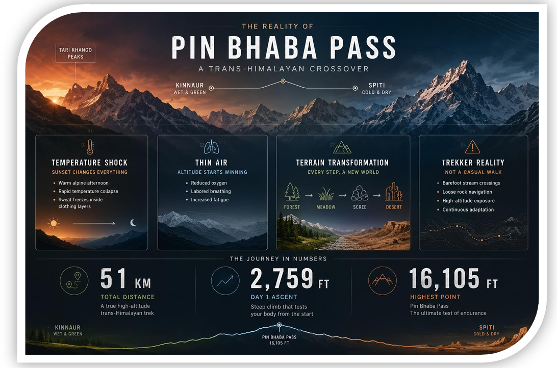
The Himalayas are generous with their drama. But few regions pack as much raw, elemental grandeur into a single valley system as the triangle formed by the Spiti, Kinnaur, and Kullu districts of Himachal Pradesh. Somewhere within this triangle lie two of India's most celebrated trans-Himalayan crossings: the Pin Bhaba Pass trek (4,865 m) and the Pin Parvati Pass trek (5,319 m).
Both treks take you from the lush, forested valleys of the Kullu side to the stark, moonscape plateaus of the Spiti valley — or vice versa. Both are wilderness routes where the trail disappears, weather turns without warning, and the silence is so complete you can hear your own heartbeat. And yet, they are remarkably different experiences, suited to different trekkers, different seasons, and different ideas of what adventure means.
This guide breaks down every dimension of the comparison — so you can make the right call before you lace up your boots.
Pin Bhaba Pass connects the Bhaba Valley (a side valley of Kinnaur's Sutlej basin) with the Pin Valley National Park in Spiti. It sits at 4,865 metres and is widely considered the most accessible of the trans-Himalayan crossings in this region.
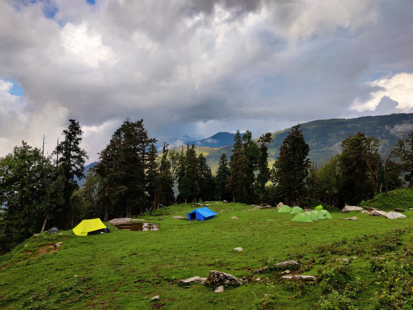
The trail winds through dense forests of oak, rhododendron, and pine in its lower sections, transitions to alpine meadows strewn with wildflowers, and finally breaks open into the high-altitude desert on the Spiti side. The contrast between the two faces of the Himalaya — one green and moist, the other barren and ancient — is experienced in miniature here.
It is a trek that rewards endurance without demanding technical mountaineering skill. Most fit, acclimatised trekkers with some prior high-altitude experience can complete it.
Pin Parvati Pass, at 5,319 metres, is in a different league. It connects the Parvati Valley (starting from Kheerganga or Barsheni, above Kasol) with the Pin Valley in Spiti. It is one of the highest trekking passes in the Indian Himalaya regularly attempted by non-technical trekkers — and it regularly humbles even seasoned mountaineers.
The Parvati side is a world of glacial moraines, snowfields, boulder fields, and a river crossing that has turned back strong parties. The Pin side descends through a stark, magnificent landscape of eroded rock and ancient villages. The pass crossing itself often involves technical glacier travel and may require crampons, ice axes, and rope skills depending on the season and year.
This is not a trek for beginners. It is, however, one of the most spectacular wilderness crossings in all of Asia.
| Feature | Pin Bhaba Pass | Pin Parvati Pass |
|---|---|---|
| Altitude | 4,865 m | 5,319 m |
| Duration | 6–8 days | 10–14 days |
| Difficulty | Moderate–Difficult | Very Difficult |
| Start Point | Kafnu (Kinnaur) | Barsheni / Kheerganga (Kullu) |
| End Point | Mudh Village, Pin Valley | Mudh Village, Pin Valley |
| Best Season | July–September | July–mid-September |
| Technical Skills Required | None | Glacier travel, crampon use |
| River Crossings | Minor stream crossings | Major, potentially dangerous |
| Guides/Porters | Recommended | Mandatory |
| Permits Required | Yes (inner line) | Yes (inner line) |
| Snowfield on Pass | Moderate | Extensive (glaciated) |
| Camping Nights | 5–6 | 9–12 |
| Nearest Base Town | Reckong Peo / Shimla | Bhuntar / Kasol |
| Crowd Level | Low | Very Low |
| Overall Wilderness Feel | High | Extreme |
Day 1 — Shimla / Reckong Peo → Kafnu (2,700 m) The journey to the trailhead takes you along the Sutlej river on the Hindustan-Tibet Highway — already spectacular. Kafnu is a small hamlet that serves as the last road-connected village.
Day 2 — Kafnu → Mulling (3,350 m) The trail climbs steeply through dense forest. Mulling is a traditional shepherd's camping ground with a flat meadow and a stream.
Day 3 — Mulling → Kara (3,600 m) A gradual climb through alpine meadows with views opening toward the Bhaba basin. Kara meadow is one of the most beautiful campsites on the route.
Day 4 — Kara → Base Camp (4,400 m) The treeline is left behind. The valley widens. Huge glacial moraines appear. This is your acclimatisation camp.
Day 5 — Base Camp → Pin Bhaba Pass (4,865 m) → Phutsirang (4,200 m) Summit day. An early alpine start, a relatively straightforward snow/scree ascent to the pass, and a long descent to the first camp on the Spiti side.
Day 6 — Phutsirang → Mudh Village (3,750 m) A satisfying walk down the Pin Valley with views of Spiti's eroded badlands, mani walls, and gompas. Mudh is the first motorable road village.
Day 7 — Mudh → Kaza (3,800 m) by jeep / bus From Kaza, connect to Shimla, Manali, or Chandigarh.
Day 1 — Bhuntar / Kasol → Barsheni → Kheerganga (3,000 m) Trek through the forested Parvati Valley to the famous hot springs at Kheerganga.
Day 2 — Kheerganga → Tunda Bhuj (3,400 m) The valley narrows and the trail becomes rougher. Dense birch forest gives way to alpine shrubs.
Day 3 — Tunda Bhuj → Odi Thach (3,750 m) Further ascent into high grazing grounds. The valley opens wide and majestic.
Day 4 — Odi Thach → Mantalai Lake (4,150 m) A highlight of the trek — Mantalai is one of the highest and most strikingly blue glacial lakes in Himachal. Many groups spend two nights here to acclimatise.
Day 5 — Acclimatisation at Mantalai Lake Rest, short exploration walks, preparation for the high camp push.
Day 6 — Mantalai Lake → High Camp (4,700 m) The terrain becomes more glacial. Navigation requires care. This is where guides earn their keep.
Day 7 — High Camp → Pin Parvati Pass (5,319 m) → Descent Camp (4,500 m) The hardest day of the entire trek. A pre-dawn start. Glacier travel. The pass offers staggering 360-degree panoramas across the Spiti, Kinnaur, and Kullu ranges. The descent on the Pin side is steep and requires careful footwork.
Day 8–10 — Descent to Mudh via Pin Valley A multi-day descent through the raw, magnificent Pin Valley, passing the ancient Kungri Monastery and traditional Spitian villages.
Day 11 — Mudh → Kaza, onward journey
Pin Bhaba demands solid aerobic fitness and the ability to carry a pack over sustained ascents. However, the daily altitude gains are manageable and the terrain — while rugged — does not require specialised skills. Trekkers who have completed routes like the Hampta Pass, Kuari Pass, or Roopkund can handle Pin Bhaba with proper preparation.
Pin Parvati is categorically harder. The longer duration, higher altitude, technical glacier crossing, and the physical and psychological challenge of multi-day wilderness camping at altitude make it one of the most demanding non-technical treks in India. Prior experience on multi-day high-altitude routes (ideally including a crossing above 5,000 m) is strongly advisable. Several fit and experienced trekkers are turned back each year — usually by the river crossing on the Parvati side or by conditions on the pass itself.
Pin Bhaba requires no ropes, ice axes, or glacier travel knowledge under normal conditions (though a walking pole is highly recommended). The pass section may have patches of hard snow requiring careful footing.
Pin Parvati may require crampons, ice axe arrest skills, and rope handling, depending on conditions. The Parvati river crossing — usually done by wading, with trekkers roped together — can be thigh-deep in strong current during peak monsoon. Many agencies decline to operate the route in August due to river levels.
Pin Bhaba has a reasonably well-defined trail for most of its length. Local shepherds use it seasonally and the route is documented by multiple agencies.
Pin Parvati loses its trail in the moraine and glacial sections above Mantalai Lake. Navigation by experienced local guides is not optional — it is essential.
Both treks feature the trademark Himalayan contrast of green-to-desert landscapes, but the intensity of that experience differs significantly.
The Bhaba Valley is deeply forested and the lower sections feel almost subalpine — wildflowers in bloom, gurgling streams, occasional wildlife sightings (Himalayan black bear, monal pheasant). The higher sections transition to classic Spiti desert scenery. The scale is intimate compared to Pin Parvati. This is a trek where you feel in the landscape.
The Parvati Valley above Kheerganga is a world unto itself. The sheer scale of the glaciers, the impossibly blue Mantalai Lake, the chaos of moraine and boulder as you approach the pass — and then the sudden, almost violent transition to the lunar Spiti plateau — is among the most dramatic landscape sequences in the Indian Himalaya. Trekkers consistently describe the pass crossing as a once-in-a-lifetime visual experience.
Best window: Mid-July to mid-September
The pass is generally snow-free from mid-July onward. Late September can see fresh snowfall that makes the pass crossing risky. August is a popular month, though the approach road can be affected by landslides during heavy monsoon years. Early July may still have significant snow on the pass.
Best window: Late July to mid-September
The route requires more narrow timing. Early July sees dangerously high river levels and unstable snow on the glacier. After mid-September, snowfall increases rapidly and the glacier becomes hazardous. The sweet spot is roughly August — but even then, river crossings must be timed to early morning when meltwater levels are lowest. The route is effectively closed October through June.
Both passes traverse sensitive border areas close to the Indo-Tibetan boundary and require Inner Line Permits (ILP) for the Spiti and Kinnaur sections.
For Indian citizens: ILPs are obtained from the Sub-Divisional Magistrate offices in Reckong Peo (for Kinnaur) or from Kaza (for Spiti). Many trekking agencies arrange these.
For foreign nationals: ILPs are required and must be obtained with a registered tour operator. Solo foreign trekking is not permitted in restricted zone areas. For Pin Parvati, additional regulations may apply since the Parvati Valley itself borders protected areas.
Check the current permit requirements before your trip, as regulations are subject to change.
Guides and porters are strongly recommended, particularly for the pass crossing day and for navigation above the treeline. Local guides from Kafnu or hired through Reckong Peo agencies are experienced and affordable. It is possible (but not advisable for first-timers) to do the route independently with solid navigation skills and a well-researched itinerary.
An experienced local guide is non-negotiable. The glacier section, river crossings, and high camp navigation have caused fatalities and required search-and-rescue operations when trekkers have attempted this without qualified guidance. Reputable agencies with specific experience on this route are essential. Ask specifically about your guide's experience on Pin Parvati — general Himalayan experience is not sufficient.
Reputable operators to research: Himalayan Treks, Bikat Adventures, Trek the Himalayas, and several Kasol-based local agencies with established guides.
The main risks are altitude sickness (particularly on pass crossing day), cold exposure in bad weather, and the general risks of remote wilderness camping. Cell phone coverage is absent for most of the route. Satellite communication devices are recommended.
Medical preparation: Acclimatise properly in Shimla or Reckong Peo. Carry Diamox (consult a doctor), a basic altitude medicine kit, and know the symptoms of HACE and HAPE.
All of the above risks apply, plus:
Carry a PLB (Personal Locator Beacon) or satellite communicator. Ensure your guide carries a first aid kit with high-altitude medications. Know your evacuation options — helicopter rescue from Pin Valley is possible but expensive and weather-dependent.
The Bhaba Valley hosts significant biodiversity. The lower forests shelter Himalayan black bear, yellow-throated marten, and diverse birdlife including the stunning Himalayan monal (state bird of Himachal Pradesh). The Pin Valley side is within Pin Valley National Park, home to the elusive snow leopard and Himalayan ibex.
The Parvati Valley is equally rich in its lower stretches. Above the treeline, ibex sightings become more frequent. The entire route essentially traces the northern boundary of the Great Himalayan National Park (a UNESCO World Heritage Site) — one of the most intact ecosystems in the western Himalaya. Leave No Trace principles are not optional here; they are a moral obligation.
There is no universally "better" pass. There is only the pass that is right for you, right now.
Pin Bhaba Pass is a magnificent trek — underrated precisely because it sits in the shadow of its more famous neighbour. It is demanding enough to be deeply satisfying, wild enough to feel genuinely remote, and achievable enough to be done by trekkers who are not mountaineers. If you are building your high-altitude experience, Pin Bhaba is a superb objective.
Pin Parvati Pass is in a class of its own. If you are an experienced, properly equipped, and professionally guided trekker seeking one of the greatest wilderness experiences in Asia, Pin Parvati will not disappoint. But it will demand everything from you — and it is unforgiving of underestimation.
Perhaps the ideal plan is this: do Pin Bhaba first. Learn the rhythm of the land, acclimatise your body and mind to trans-Himalayan wilderness, and let the landscape earn your respect. Then return for Pin Parvati — and cross it knowing you've truly earned the view from 5,319 metres.
Getting to the trailheads:
Pin Bhaba: Fly or train to Shimla → drive to Reckong Peo (8–9 hrs) → local taxi to Kafnu (2 hrs)
Pin Parvati: Fly to Bhuntar (near Kullu-Manali airport) → bus/taxi to Kasol (1.5 hrs) → shared taxi to Barsheni (30 mins)
Exiting (both treks end at Mudh, Pin Valley):
Mudh → Kaza by shared jeep (3–4 hrs) → Kaza to Shimla (14–16 hrs bus) or Manali (8–9 hrs bus)
Packing Essentials for Both: