30
Apr

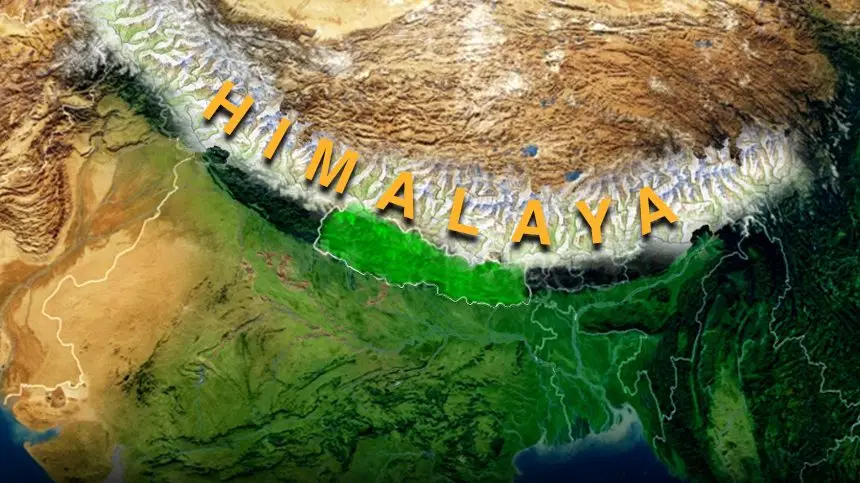
1.The Himalayas are a mountain range in Asia, separating the Indian subcontinent from the Tibetan Plateau. The name "Himalaya" means "the abode of snow" in Sanskrit.
2. The Himalayan mountain range is the highest and youngest on earth and is home to more than one hundred mountain peaks exceeding 7,200. metres (23,600 ft) in altitude. It is also home to all of the planet's 14 peaks exceeding 8,000 meters, including the highest, Mount Everest.
3. The Himalayas stretch across five nations: India, Tibet, Bhutan, Nepal, and Pakistan. It is the source of three of the world's major river systems: the Indus Basin, the Ganga- Brahmaputra Basin and the Yangtze Basin.
4. The Himalayas themselves stretch uninterruptedly for about 2,400 km from West to East between Kashmir and Northeast India. The width of the Himalayas from South to North varies between 200 and 400 km. The total area amounts to about 5, 95,000 square km.
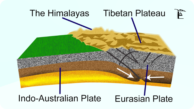
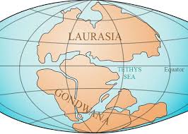
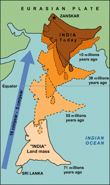
(a) About 270 million years ago the Earth was one big land mass (super continent) called Pangea. The giant ocean that surrounded Pangea was called Panthalassa. Around 200 million years ago Pangea started to break up. Pangea first separated into two continents. The Northern one was called Laurasia and the Southern one was called Gondwanaland. They were separated by the Tethys Sea. Between 120 to 180 million years ago both Laurasia and Gondwanaland began to further separate and as a part of this process the Indian sub continent broke away from Gondwanaland and started drifting Northwards. The movement occurred @ of 10-15 cm/yr.
(b) 60 Million years ago, the Indian Subcontinent collided with the Eurasian landmass. The plate containing India was sheared downwards. During the next 30 million years, the Eurasian plate was pushed up by the plunging Indian Plate; this formed the Plateau of Tibet. And on the plateau's Southern edge, the top layer of the Indian plate folded and rose upwards. This formed the Himalayan ranges of today. Himalayas are one of the youngest mountains systems of the world. Probably only within the past 600,000 years, did the Himalayas become the highest mountains.
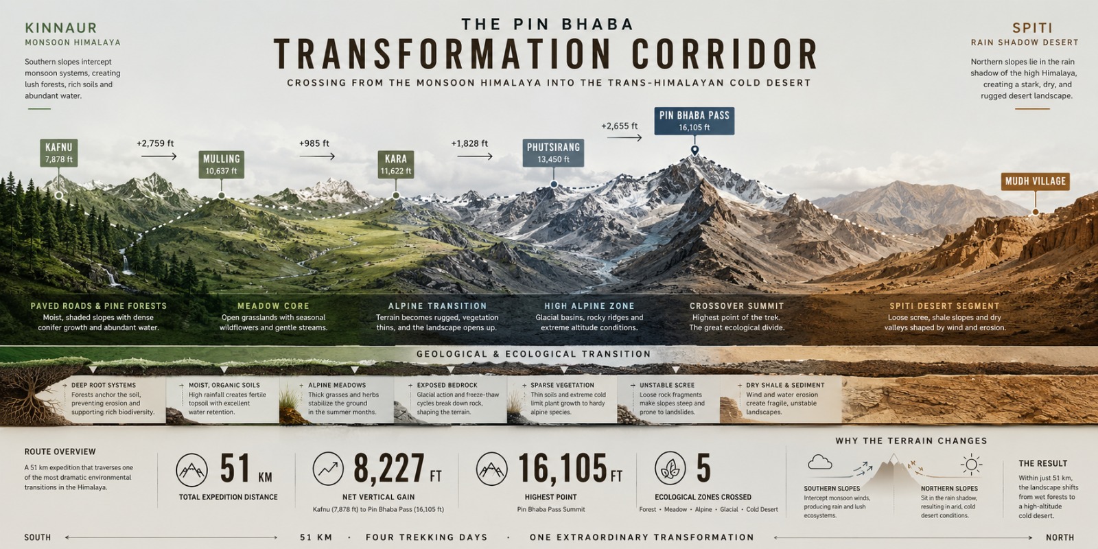
(a) The Himalayan ranges can be divided length wise into three parallel mountain belts of varying width. They are designated, from South to North, as the Outer, or Sub Himalayas (also called the Siwalik Range); the Lesser of Lower Himalayas, and the Greater Himalayas
(b) The Western frontier of the Himalayas is the Nanga parbat in Pakistan occupied Kashmir towering at 8126 M. The Eastern frontier is marked by Namche Barwa in India. standing at 7756 M.
Also called Shivalik Hills or Outer Himalayas, they extend west and north-Westward for more than 1,000 miles (1,600 km) from the Teesta River in Sikkim. Though only 10 miles (16 km) wide in places, the range has an average elevation of 3,000 to 4,000 feet (900 to 1200 metres).
Also called Inner Himalayas, Lower Himalayas, or Middle Himalayas. They are the middle section of the Himalayan mountain ranges, extending South-Eastward across Pak Occupied Kashmir (POK), North India, Nepal, Sikkim, and into Bhutan.
Also called Higher Himalayas or Great Himalayan Range, are the highest and Northern most section of the Himalayan mountain ranges. It extends South Eastward across Pak Occupied Kashmir (POK), Northern India, and Nepal before turning Eastward across Sikkim, Bhutan, and finally turning North-Eastward across Northern Arunachal Pradesh. The Greater Himalayas contain many of the world's tallest peaks, including (from West to East) Nanga Parbat, Annapurna, Mount Everest, and Kanchenjunga
Sir Sidney Burrard divided the entire length of the Himalayas into the following four divisions on the basis of the river valleys:-
The 560 km long stretch of the Himalayas between the Indus and the Satluj rivers is known as Punjab Himalayas. Famous peaks are Nanga Parbat, Nun and Kun
They lie between the Satluj and the Kali rivers.
They are 320 km long. Nanda Devi, Kamet, Trishul, Gangotri are important peaks.
This section of Himalayas stretches for a distance of 800 km from the Kali River to the Teesta River. Important peaks include Mount Everest, Kanchenjunga, Makalu and Lhotse.
A 750 km stretch of Himalayas located between the Teesta and the Brahmaputra rivers is called the Assam Himalayas. Namcha Barwa, Kula Kangri, Chomo Lhari are important peaks of this region.
The Himalayas have a profound effect on the climate of 8.
the Indian subcontinent and the Tibetan Plateau. They prevent cold, dry winds from blowing South into the Indian subcontinent, which keeps South Asia much warmer than corresponding temperate regions in the other continents.
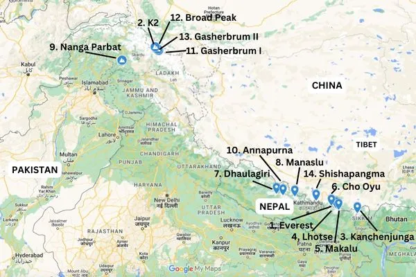
There are only 14 mountains on Earth that have more than 8,000 metres (26,247 ft) elevation above sea level. All eight-thousanders are located in the Greater Himalayas. +
(a) The first person to climb all 14 eight-thousanders was Reinhold Messner.
(b) The list of the fourteen 8000 meter peaks is as under: -